
Laroque-des-Albères
|
Laroque-des-Albères La Roca d'Albera |
||
|---|---|---|
.svg)
|
|
|
| region | Occitania | |
| Department | Pyrénées-Orientales | |
| Arrondissement | Ceret | |
| Canton | Vallespir-Albères | |
| Community association | Albères, Côte Vermeille et l'Illibéris | |
| Coordinates | 42 ° 31 ' N , 2 ° 56' E | |
| height | 31-1,256 m | |
| surface | 20.51 km 2 | |
| Residents | 2,112 (January 1, 2017) | |
| Population density | 103 inhabitants / km 2 | |
| Post Code | 66740 | |
| INSEE code | 66093 | |
| Website | http://www.laroque-des-alberes.fr | |

Laroque-des-Albères ( La Roca d′Albera in Catalan ) is a French commune with 2112 inhabitants (as of January 1, 2017) in the Pyrénées-Orientales department of the Occitania region . It belongs to the Arrondissement of Céret and the canton of Vallespir-Albères .
Laroque lies at the foot of the Pyrenees , partly in the plain, partly on the mountainside. The highest point is the Pic de Néoulous (Puig Neulos) with 1256 meters.
Population development
- 1962: 853
- 1968: 831
- 1975: 984
- 1982: 1,126
- 1990: 1,508
- 1999: 1,909
- 2007: 1,968
Attractions
- Castle ruins
- La Roca Castle
- Church Saint-Félix et Saint-Blaise (13th century) with a baroque - altarpiece
- Notre-Dame de Tanya chapel (13th century)
- Ruins of the Saint-Fructueux de Roca-Vella chapel (probably 9th century)
- Dolmen Balma del Moro

Place view

The village as seen from the château

The chateau, 12th century (from SW)
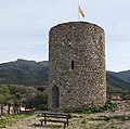
The tower of the château (from the northwest)

The Saint-Félix et Saint-Blaise church

Bell gable seen from the west

Marble bust of St. Paul at the portal of the church

Marble bust of St. Peter at the portal of the church

Notre-Dame de Tanya chapel (east view)

Notre-Dame de Tanya chapel (west view)

The ruins of the Saint-Fructueux de Roca-Vella chapel

The Romanesque chapel of Saint-Sébastien


.jpg)


.jpg)

