
Trouillas
|
Trouillas trullars |
||
|---|---|---|

|
|
|
| region | Occitania | |
| Department | Pyrénées-Orientales | |
| Arrondissement | Ceret | |
| Canton | Les Aspres | |
| Community association | Aspres | |
| Coordinates | 42 ° 37 ′ N , 2 ° 49 ′ E | |
| height | 58-152 m | |
| surface | 17.01 km 2 | |
| Residents | 2,067 (January 1, 2017) | |
| Population density | 122 inhabitants / km 2 | |
| Post Code | 66300 | |
| INSEE code | 66217 | |
| Website | http://www.trouillas.fr/ | |

Trouillas ( Occitan and Catalan : Trullars ) is a French commune in the department of Pyrenees-Orientales in the region Occitania . Administratively it is assigned to the canton of Les Aspres (until 2015: canton of Thuir ) and the arrondissement of Céret . The 2,067 inhabitants (as of January 1, 2017) are called Trouillasencs .
geography
Trouillas is located about 12 kilometers south-southwest of Perpignan on the Canterrane . Trouillas is surrounded by the neighboring communities of Ponteilla in the north, Villemolaque in the south and east, Passa in the south, Fourques in the south-west, Terrats in the west and Llupia in the north-west. The wine-growing regions of Rivesaltes and Côtes du Roussillon extend into the municipality .
The A9 car route runs along the eastern edge of the municipality .
Population development
| year | 1962 | 1968 | 1975 | 1982 | 1990 | 1999 | 2006 | 2012 |
|---|---|---|---|---|---|---|---|---|
| Residents | 1,088 | 1,070 | 1,075 | 1,144 | 1,272 | 1,424 | 1,538 | 1,875 |
| Source: Cassini and INSEE | ||||||||
Attractions
- Romanesque church of Saint-Assiscle
- Le Mas Deu headquarters of the Knights Templar, founded in 1138, abandoned in 1312 when the order became extinct

Saint-Assiscle Church
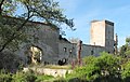
Headquarters of the Templars

