
Sorède
|
Sorède Sureda |
||
|---|---|---|

|
|
|
| region | Occitania | |
| Department | Pyrénées-Orientales | |
| Arrondissement | Ceret | |
| Canton | Vallespir-Albères | |
| Community association | Albères, Côte Vermeille et l'Illibéris | |
| Coordinates | 42 ° 33 ' N , 2 ° 55' E | |
| height | 42-1,241 m | |
| surface | 34.54 km 2 | |
| Residents | 3,267 (January 1, 2017) | |
| Population density | 95 inhabitants / km 2 | |
| Post Code | 66740 | |
| INSEE code | 66196 | |
 View of the center of Sorède |
||

Sorède ( Sureda in Catalan ) is a French commune with 3267 inhabitants (as of January 1, 2017) in the Pyrénées-Orientales department in the Occitania region ; it belongs to the Arrondissement of Céret and the canton of Vallespir-Albères .
geography
Sorède lies at the foot of the Pyrenees , with more than two thirds of the municipality being mountainous. Three ranges of hills enclose two valleys, the Vallée de La Fargue in the west and the Vallée de Lavail in the east. The highest peak is the Pic Néoulos (Puig Neulos) with 1257 meters.
Population development
- 1962: 1,138
- 1968: 1,164
- 1975: 1,491
- 1982: 1,896
- 1990: 2.160
- 1999: 2,704
- 2007: 2,970
Attractions
- The church of Saint-Assiscle et Sainte-Victoire, first mentioned in 1052, rebuilt in the 14th century, a third building in the 1730s.
- Notre-Dame-du-Château chapel (18th century)
- Ruins of the Château d'Ultère (8th - 15th centuries)
- Saint-Martin de Lavall church (9th / 10th century)
- Valley of the Turtles
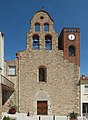
Parish Church of Saint-Assiscle et Sainte-Victoire

Romanesque church of Saint-Martin de Lavall

Portal of the chapel of Notre-Dame du Château d'Ultrera


Individual evidence
Web links
Commons : Sorède - collection of images, videos and audio files