
Lamanère
| Lamanère | ||
|---|---|---|
.svg)
|
|
|
| region | Occitania | |
| Department | Pyrénées-Orientales | |
| Arrondissement | Ceret | |
| Canton | Le Canigou | |
| Community association | Haut Vallespir | |
| Coordinates | 42 ° 22 ′ N , 2 ° 31 ′ E | |
| height | 667-1,554 m | |
| surface | 23.83 km 2 | |
| Residents | 46 (January 1, 2017) | |
| Population density | 2 inhabitants / km 2 | |
| Post Code | 66230 | |
| INSEE code | 66091 | |
 Sainte-Sauveur church |
||

Lamanère is a French commune with 46 inhabitants (as of January 1, 2017) in the Pyrénées-Orientales department in the Occitanie region . It belongs to the Arrondissement of Céret and the canton of Le Canigou .
geography
Lamanère is located in the Pyrenees and is the southernmost municipality in the Pyrénées-Orientales department. Lamanère's neighboring municipalities are Serralongue in the northeast, Albanyà (Spain) in the southeast, Montagut i Oix (Spain) in the south, Camprodon (Spain) in the southwest and Prats-de-Mollo-la-Preste in the northwest.
Population development
| year | 1962 | 1968 | 1975 | 1982 | 1990 | 1999 | 2013 |
| Residents | 198 | 113 | 74 | 60 | 37 | 44 | 47 |
Attractions
- Tours de Cabrenç
- Romanesque church of Sainte-Christine
- Romanesque church of Saint-Sauveur

Sainte-Christine church
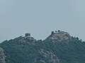
Tours de Cabrenç


Web links
Commons : Lamanère (Pyrénées-Orientales) - Collection of images, videos and audio files