
Montagut i Oix
| Montagut i Oix municipality | |||
|---|---|---|---|
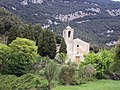
 Montagut i Oix - Church of Sant Aniol d'Aguja
|
|||
| coat of arms | Map of Spain | ||

|
|
||
| Basic data | |||
| Autonomous Community : | Catalonia | ||
| Province : | Girona | ||
| Comarca : | Garrotxa | ||
| Coordinates | 42 ° 14 ' N , 2 ° 36' E | ||
| Height : | 276 msnm | ||
| Area : | 93.69 km² | ||
| Residents : | 916 (Jan. 1, 2019) | ||
| Population density : | 9.78 inhabitants / km² | ||
| Postal code : | 17855 | ||
| Municipality number ( INE ): | 17109 | ||
| administration | |||
| Website : | montagut-oix.cat | ||


Montagut i Oix is a place and a municipality ( municipi ) with 916 inhabitants (as of January 1, 2019) in the province of Girona in the autonomous region of Catalonia .
location
The municipality of Montagut i Oix, which consists of around a dozen villages and hamlets, is located at an altitude of around 250 to 300 meters above sea level. d. M. in the wooded area of the southern foothills of the Spanish Pyrenees . Part of the municipality belongs to the L'Alta Gerrotxa Nature Park . The community, which is comparatively large in area, is about 56 kilometers (driving distance) to the northwest from Girona and about 49 kilometers to the west from Figueres . The listed medieval town of Besalú is located about 23 kilometers (driving distance) to the southeast.
Population development
Due to the large number of incorporations, reliable figures on population development are only available from 1998; accordingly, the population fluctuated between 1998 and 2013 between 800 and 1,000 inhabitants,
economy
In the past, the inhabitants lived mainly as self-sufficient farmers from agriculture , which also included keeping cattle. Montagut and Oix also served as craft and mercantile centers for several villages and hamlets in the area.
history
Although Montagut and Oix merged in 1972, the parish only adopted its new name in 2002.
Attractions
- Remnants of walls and a round tower still stand from the former Montagut castle .
- The castle of Oix is much better preserved and partly inhabited.
- The monastery of Sant Aniol d'Aguja ( 42 ° 19 ′ 0.9 ″ N , 2 ° 35 ′ 16.8 ″ E ), already mentioned in the 9th century, received a new church in the 11th century, which is mostly made of rubble . The apse is structured by pilaster strips and round arches in the Lombard architectural style ; the west facade, on the other hand, is unstructured and unadorned - there is only a round window above the portal. A small, later added brick bell gable ( espadanya ) towers over the single-nave building.
- There are several smaller Romanesque churches, chapels and hermitages in the large municipal area .

Nostra Senyora de les Agulles
Sant Martì de Talaixà

Ermita de Sant Miquel Sesvinyes


Web links
Individual evidence
- ↑ Cifras oficiales de población resultantes de la revisión del Padrón municipal a 1 de enero . Population statistics from the Instituto Nacional de Estadística (population update).
Argelaguer | Besalú | Beuda | Castellfollit de la Roca | Maià de Montcal | Mieres | Montagut i Oix | Olot | Les Planes d'Hostoles | Les Preses | Riudaura | Sales de Llierca | Sant Aniol de Finestres | Sant Feliu de Pallerols | Sant Ferriol | Sant Jaume de Llierca | Sant Joan les Fonts | Santa Pau | Tortellà | La Vall de Bianya | La Vall d'en Bas