Garrotxa
| Garrotxa | |
|---|---|

|
|
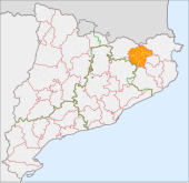
| The location of the Comarca Garrotxa in Catalonia | |
| Basic data | |
| Province: | Girona |
| Main place: | Olot |
| Surface: | 735.4 km² |
| Residents: | 57,590 (2019) |
| Municipalities: | 21st |
The Comarca Garrotxa is located in the province of Girona of the Autonomous Community of Catalonia ( Spain ). The community association has an area of 735.4 km² and 57,590 inhabitants (2019).
location
The association of municipalities is located in the eastern part of Catalonia, northwest of the provincial capital Girona . It borders in the north-east on the Comarca Alt Empordà , in the east on Pla de l'Estany , in the south-east on Gironès , in the south on Selva , in the south-west on Osona , in the north-west on Ripollès and in the far north on the Republic of France . Together with the comarcas Alt Empordà, Baix Empordà , Gironès, Pla de l'Estany, Selva and Ripollès, the region forms the territory of Comarques Gironines . Barcelona is about 150 km southwest.
The district is located in the Pyrenees and can be divided into two scenic zones by the Fluvià river : The Alta Garrotxa (German: Upper Garrotxa), in the western and northern parts, forms a rugged, rocky and impassable area with gorges, crevices and caves . The basin of the Fluvià and its tributaries in the southeastern part of the Comarca form the Baixa Garrotxa (Eng .: Lower Garrotxa), with pastures, forests and streams.
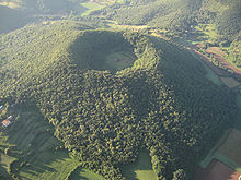
In the center of the district is the Garrotxa Volcanoes Nature Reserve , a landscape with more than forty wooded volcanoes , the crater edges of which rise between 10 and 160 m. The diameter of the crater varies from 300 to 1,500 m. The Croscat volcano last erupted about 11,500 years ago. In 1985 the Catalan Parliament declared the volcanic zone a natural park.
vegetation
Dominant trees are oak , cork oak , holm oak and beech .
economy
The most important branch of the economy is cattle breeding, especially the keeping of cattle on pastures, but also of pigs and sheep. Industrial companies in the textile, meat, paper and leather industries have settled in the comarca.
Communities
Status: 2019
| local community | Pop. | Area (km²) |
local community | Pop. | Area (km²) |
local community | Pop. | Area (km²) |
||
|---|---|---|---|---|---|---|---|---|---|---|
| Argelaguer | 397 | 12.72 | Olot | 35,228 | 29.07 | Sant Ferriol | 243 | 41.69 | ||
| Besalú | 2492 | 4.77 | Les Planes d'Hostoles | 1683 | 36.97 | Sant Jaume de Llierca | 865 | 7.11 | ||
| Beuda | 190 | 35.53 | Les Preses | 1788 | 9.43 | Sant Joan les Fonts | 3006 | 31.98 | ||
| Castellfollit de la Roca | 961 | 0.67 | Riudaura | 478 | 24.10 | Santa Pau | 1565 | 48.84 | ||
| Maià de Montcal | 449 | 16.88 | Sales de Llierca | 154 | 36.29 | Tortellà | 809 | 10.93 | ||
| Mieres | 318 | 26.12 | Sant Aniol de Finestres | 341 | 47.56 | La Vall de Bianya | 1264 | 93.85 | ||
| Montagut i Oix | 916 | 93.69 | Sant Feliu de Pallerols | 1371 | 34.99 | La Vall d'en Bas | 3072 | 90.61 |
See also
Web links
- Comarca website (Catalan)
- Association of municipalities (Catalan, Spanish, English, German, French, Italian)
- Turisme (Catalan, Spanish, English, French)
- gencat-Turisme (Catalan, Spanish, English, German, French)
- IDESCAT: statistical information on the Comarca Garrigues
- Merten Worthmann: Everything in the green area (article about the Garrotxa), in: Zeit-Online, from July 29, 2004

