Pla de l'Estany
| Pla de l'Estany | |
|---|---|

|
|
| The location of the Comarca Pla de l'Estany in Catalonia | |
| Basic data | |
| Province: | Girona |
| Main place: | Banyoles |
| Surface: | 262.8 km² |
| Residents: | 32,293 (2019) |
| Municipalities: | 11 |
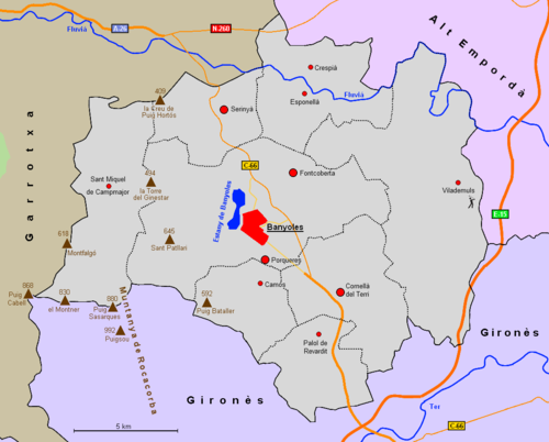
The Comarca Pla de l'Estany is located in the province of Girona in the Autonomous Community of Catalonia ( Spain ). The community association has an area of 262.8 km² and 32,293 inhabitants (2019). The name Pla de l'Estany means place of the lake, this is the lake of Banyoles. Originally, the community association was part of the Comarca Gironès and only became independent in 1988 following a referendum.
location
The association of municipalities is located in the eastern part of Catalonia, north of the provincial capital Girona . It borders on the comarca Alt Empordà in the north, Gironès in the south and Garrotxa in the west . Together with the comarcas Alt Empordà, Baix Empordà , Garrotxa, Gironès, Selva and Ripollès , the region forms the territory of Comarques Gironines .
The Estany de Banyoles forms the center of Pla de l'Estany. The eastern part lies in a fertile plain, which borders the Fluvià river in the north and in the drainage area of the Terri river in the south . The western part of the comarca lies in the ridges of the Serra de Rocacorba .
Communities
Status: 2019
| local community | Residents | Area (km²) |
local community | Residents | Area (km²) |
|
|---|---|---|---|---|---|---|
| Banyoles | 19,826 | 10.91 | Palol de Revardit | 455 | 18.35 | |
| Camos | 693 | 15.35 | Porqueres | 4621 | 33.71 | |
| Cornellà del Terri | 2364 | 27.84 | Sant Miquel de Campmajor | 231 | 33.43 | |
| Crespià | 246 | 11.28 | Serinyà | 1136 | 17.41 | |
| Esponellà | 438 | 16.13 | Vilademuls | 815 | 61.72 | |
| Fontcoberta | 1468 | 17.21 |
See also
Web links
- Comarca website (Catalan)
- Association of municipalities (Catalan, Spanish, English, German, French, Italian)
- Turisme (Catalan, Spanish, English, French)
- gencat-Turisme (Catalan, Spanish, English, German, French)
- IDESCAT: statistical information on the comarca

