Conca de Barberà
| Conca de Barberà | |
|---|---|

|
|
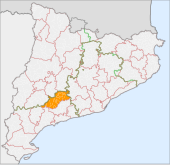
| The location of the Comarca Conca de Barberà in Catalonia | |
| Basic data | |
| Province: | Tarragona |
| Main place: | Montblanc (Tarragona) |
| Surface: | 650.24 km² |
| Residents: | 20,042 (2019) |
| Municipalities: | 22nd |
The Comarca Conca de Barberà is located in the province of Tarragona of the Autonomous Community of Catalonia ( Spain ). The community association has an area of 650 km² and 20,042 inhabitants (2019).
location
The association of municipalities is located in the central part of Catalonia, between the provincial capitals Tarragona and Lleida . It borders in the north on the comarca of Urgell and Segarra , in the east on Anoia , in the south on Alt Camp , and in the west on Baix Camp , Priorat and Garrigues . Together with the comarcas Alt Camp, Baix Camp, Baix Penedès , Priorat and Tarragonès , the region forms the territory of Camp de Tarragona .
Conca de Barberà is located in a basin (katal .: conca) through which several small rivers flow. In the west this is the upper reaches of the Ríu Francolí with its tributary Anguera. In the east lies the upper reaches of the Ríu Gaiá . The plain is surrounded by low mountain ranges, in the north these are the mountain ranges Tallat and Suro, in the east Brufaganya and Queralt, in the south Miramar and Cogullo and in the west Llena and the Prades Mountains. In the Prades Mountains there are several mountain peaks of over 1,000 m, including the highest point of the community association, the Tossal de la Baltasana (1,201 m) on the border with the Comarca Baix Camp.
economy
The main industry is agriculture. Grains, wine, hazelnuts, almonds and vegetables are grown. Conca de Barberà is also an appellation of origin for a wine from this region with the classification DO (Denominación de Origen). Pigs and poultry are raised in the livestock industry. Industry is of little concern.
Communities
Status: 2019
| local community | Pop. | Area (km²) |
local community | Pop. | Area (km²) |
local community | Pop. | Area (km²) |
||
|---|---|---|---|---|---|---|---|---|---|---|
| Barberà de la Conca | 473 | 26.32 | Les Piles | 212 | 22.51 | Solivella | 633 | 21.28 | ||
| Blancafort | 389 | 14.49 | Pira | 493 | 8.09 | Vallclara | 98 | 13.38 | ||
| Conesa | 103 | 29.04 | Pontils | 117 | 67.62 | Vallfogona de Riucorb | 91 | 10.95 | ||
| Espluga de Francolí | 3755 | 57.17 | Rocafort de Queralt | 225 | 8.56 | Vilanova de Prades | 112 | 21.34 | ||
| Fores | 43 | 16.54 | Santa Coloma de Queralt | 2673 | 34.05 | Vilaverd | 452 | 12.53 | ||
| Llorac | 100 | 23.35 | Sarral | 1548 | 52.09 | Vimbodí i Poblet | 892 | 65.80 | ||
| Montblanc | 7364 | 91.43 | Savallà del Comtat | 58 | 14.74 | |||||
| Passer-by i Belltall | 163 | 27.35 | Senan | 48 | 11.82 |
See also
Web links
- Comarca website (Catalan, Spanish, English, French)
- Association of municipalities (Catalan, Spanish, English, German, French, Italian)
- Turisme (Spanish, English, French)
- gencat-Turisme (Catalan, Spanish, English, German, French)
- Attractions
- IDESCAT: statistical information on the Comarca Conca de Barberà
