Argelaguer
| Argelaguer municipality | ||
|---|---|---|
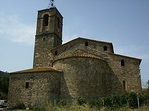
 Argelaguer - Church of Santa Maria
|
||
| coat of arms | Map of Spain | |

|
|
|
| Basic data | ||
| Autonomous Community : | Catalonia | |
| Province : | Girona | |
| Comarca : | Garrotxa | |
| Coordinates | 42 ° 13 ' N , 2 ° 38' E | |
| Height : | 183 msnm | |
| Area : | 12.72 km² | |
| Residents : | 397 (Jan. 1, 2019) | |
| Population density : | 31.21 inhabitants / km² | |
| Postal code : | 17853 | |
| Municipality number ( INE ): | 17010 | |
| administration | ||
| Website : | webspobles.ddgi.cat/sites/argelaguer/default.aspx | |
Argelaguer is a place and a municipality ( municipi ) with 397 inhabitants (as of January 1, 2019) in the province of Girona in the autonomous region of Catalonia .
location
Argelaguer is located in a wooded area on the north bank of the Río Fluvià at the foot of the Spanish Pyrenees . The at a height of about 180 meters above sea level. d. M. is located about 38 kilometers (driving distance) northwest of Girona or about 30 kilometers west of Figueres . The listed medieval town of Besalú is only about five kilometers south-east.
Population development
| year | 1960 | 1970 | 1981 | 1990 | 2000 | 2006 |
| Residents | 565 | 464 | 360 | 349 | 379 | 418 |
In the 19th century the community had over 1,000 inhabitants at times. The phylloxera crisis in viticulture and the progressive mechanization of agriculture have since led to a significant decline in the population.
economy
In the past, the inhabitants lived mainly as a self-sufficient living from agriculture , which also included growing wine and keeping cattle. In addition, the place guarded by a castle ( castell ) served as an artisanal and mercantile center of several villages and hamlets in the area.
history
The place name appears for the first time in a document from the year 982.
Attractions
- Both the apse and the western facade of the - mostly of rubble built - Romanesque parish church ( Esglesia Santa Maria ) are completely unarticulated and unadorned. The church building was redesigned in the 16th century: The portal of the west facade with its two set columns is made of light limestone; In the tympanum field there is a shell ornament, which is covered by profiled arches. The upper floor of the almost free-standing bell tower ( campanar ) on the south side and the sacristy on the north side also seem to be later additions.
- The single-nave chapel of Santa Anna dates from the 15th century, despite the rubble stone used.
- The now privately owned residential tower of Castell d'Argelaguer belongs to the same period .
- Outside the village, Josep Pujiula, born in 1937, built a fantasy garden ( laberint ) out of stone, wooden scaffolding and plants.
literature
- Vicenç Buron: Esglésies Romàniques Catalanes. Artestudi Edicions, Barcelona 1977, ISBN 84-85180-06-2 , p. 162.
Web links
- Argelaguer, Labyrinth - Photos + Info (English)
- Argelaguer, Labyrinth - Photos + Info (English)
Individual evidence
- ↑ Cifras oficiales de población resultantes de la revisión del Padrón municipal a 1 de enero . Population statistics from the Instituto Nacional de Estadística (population update).
