Banyuls-dels-Aspres
|
Banyuls-dels-Aspres Banyuls dels Aspres |
||
|---|---|---|

|
|
|
| region | Occitania | |
| Department | Pyrénées-Orientales | |
| Arrondissement | Ceret | |
| Canton | Les Aspres | |
| Community association | Aspres | |
| Coordinates | 42 ° 34 ' N , 2 ° 52' E | |
| height | 41-124 m | |
| surface | 10.53 km 2 | |
| Residents | 1,259 (January 1, 2017) | |
| Population density | 120 inhabitants / km 2 | |
| Post Code | 66300 | |
| INSEE code | 66015 | |
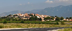
 View of the village of Banyuls-dels-Aspres, with the foothills of the Serra de l'Albera in the background |
||
Banyuls-dels-Aspres ( Catalan Banyuls dels Aspres ) is a French commune with 1259 inhabitants (as of January 1, 2017) in the Pyrénées-Orientales department of the Occitania region . It belongs to the Arrondissement of Céret and the canton of Céret .
geography
The municipality is located around 15 kilometers south-southwest of Perpignan in the Roussillon countryside . Neighboring municipalities are Saint-Jean-Lasseille in the north, Brouilla in the east, Villelongue-dels-Monts in the south-east, Montesquieu-des-Albères in the south, Tresserre in the west and Villemolaque in the north-west. The municipality is located in the wine-growing region of Côtes du Roussillon , on the southern municipality border runs the Tech River .
Transport links
The municipality of Banyouls-dels-Aspres is crossed by several arteries:
- A9 motorway from Orange to the Spanish border
- Departmental road D900 from Perpignan to Le Boulou
- Perpignan-Figueres high-speed rail line
- Railway line from Elne to Saint-Jean-Pla-de-Corts
Population development
| year | 1968 | 1975 | 1982 | 1990 | 1999 | 2006 | 2016 |
| Residents | 724 | 683 | 660 | 850 | 1.007 | 1,136 | 1,253 |

