
Serra de l'Albera
| Serra de l'Albera (Massif des Albères) |
||
|---|---|---|
 The north side of the Serra de l'Albera from Saint-Génis-des-Fontaines |
||
| Highest peak | Puig Neulós ( 1256 msnm ) | |
| location |
Girona Province , Spain Pyrenees-Orientales , France |
|
| part of | Pyrenees | |
|
||
| Coordinates | 42 ° 29 ′ N , 2 ° 57 ′ E | |

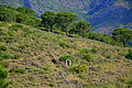
The Serra de l'Albera ( French : Massif des Albères ) is a mountain range in the north of Catalonia , on the border between France and Spain . It is the easternmost stretch of the Pyrenees and extends to the Mediterranean . The highest mountain in the mountain range is the Puig Neulós ( French : Pic du Néoulous ) with a height of 1256 m. Other well-known mountains are the Puig dels Pastors (1167 m), the Puig dels Quatre Termes (1156 m) and the Pico de Sallafort (992 m).
history
In ancient times, the Albéres Mountains formed the south-western border of the Roman territory of Septimania ; since the Peace of the Pyrenees (1659) it has been the natural border between France and Spain.
Attractions
A large area on the southern side of the mountain range has been part of the Spanish nature reserve Paratge Natural d'Interès Nacional de l'Albera since 1986 . The Serra de l'Albera has the largest concentration of megalithic monuments in Catalonia (110 dolmens, 19 menhirs, 7 stone boxes and a Neolithic settlement - and especially on the north side - several hermit churches).
Serra de l'Albera
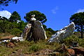
Dolmen of Serra de l'Albera

Serra de l'Albera

Serra de l'Albera
_-_4.jpg)
_-_2.jpg)
_-_3.jpg)
_-_1.jpg)