
Le Boulou
|
Le Boulou El Voló |
||
|---|---|---|
.svg)
|
|
|
| region | Occitania | |
| Department | Pyrénées-Orientales | |
| Arrondissement | Ceret | |
| Canton | Vallespir-Albères | |
| Community association | Vallespir | |
| Coordinates | 42 ° 31 ′ N , 2 ° 50 ′ E | |
| height | 55-363 m | |
| surface | 14.42 km 2 | |
| Residents | 5,514 (January 1, 2017) | |
| Population density | 382 inhabitants / km 2 | |
| Post Code | 66160 | |
| INSEE code | 66024 | |
 Le Boulou |
||

Le Boulou ( El Voló in Catalan ) is a French commune with 5514 inhabitants (as of January 1, 2017) in the Pyrénées-Orientales department of the Occitania region . It is located south of Perpignan on the Tech River in the northern Pyrenees .
geography

Attractions
One of the sights is the 11th-century Sainte Marie church with its white marble portal from nearby Céret . It is crowned by a frieze that is supported by seven consoles . These are works by the Master of Cabestany , an anonymous sculptor from the 12th century. The scenes describe, from left to right, some episodes from Jesus' childhood : the Annunciation to the Shepherds, the Birth, the Presentation in the Temple, the Adoration of the Magi, the Flight into Egypt and the Refuge there.
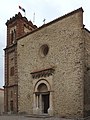
Parish Church of Sainte Marie

Portal of the Sainte Marie church


traffic
An important rail terminal for combined transport is located in Le Boulou ( ). It is conveniently located on the A9 autoroute from Spain. The Le Boulou terminal is connected to Bettembourg (Luxembourg) and Dover (England) by regular train connections . The trucks are loaded onto Modalohr wagons.
![]()
Web links
Individual evidence
- ↑ lorry-rail.com: The route
- ↑ lorry-rail.com: Technology