Montesquieu-des-Albères
|
Montesquieu-des-Albères Montesquiu d'Albera |
||
|---|---|---|

|
|
|
| region | Occitania | |
| Department | Pyrénées-Orientales | |
| Arrondissement | Ceret | |
| Canton | Vallespir-Albères | |
| Community association | Albères, Côte Vermeille et l'Illibéris | |
| Coordinates | 42 ° 31 ' N , 2 ° 53' E | |
| height | 43-1,001 m | |
| surface | 17.06 km 2 | |
| Residents | 1,224 (January 1, 2017) | |
| Population density | 72 inhabitants / km 2 | |
| Post Code | 66740 | |
| INSEE code | 66115 | |
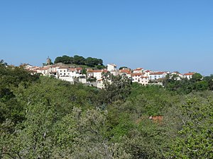
 Montesquieu-des-Albères - View of the town |
||
Montesquieu-des-Albères ( Catalan and Occitan : Montesquiu d'Albera ) is a French commune with 1,224 inhabitants (as of January 1, 2017) in the Pyrénées-Orientales department of the Occitania region .
etymology
The place was formerly called Vilanova (854). The name Montesquieu is first passed down from 1587.
location
Montesquieu-des-Albères is located in the up to 1000 meter high mountain range of the Albères, a western foothill of the Pyrenees. From Perpignan it is about 35 kilometers (driving distance) in a southern direction from Elne about 20 kilometers in a south-westerly direction. The two small towns of St-André-de-Sorède and Saint-Génis-des-Fontaines with their famous Romanesque tympana are about 13 kilometers and 7 kilometers northeast of Montesquieu, respectively.
Population development
| year | 1968 | 1975 | 1982 | 1990 | 1999 | 2007 |
| Residents | 333 | 329 | 510 | 753 | 824 | 1,142 |
The steady increase in population is due to the fact that some French have built small retirement homes in the area and now live there.
economy
In addition to some agriculture and viticulture, which are essentially only for self-sufficiency, the residents of Montesquieu live on pensioners and other immigrants from other parts of France.
history
In ancient times the Via Domitia only passed Montesquieu for a few kilometers; In the neighboring parish of Ste-Marie-du-Vilar there are still remains of a Roman watchtower. Around the year 1080 a castle was built in the vicinity of Montesquieu, of which ruins can still be seen. The church of St-Saturnin was built only a little later. From the year 1385 there is a message that the sale of several villages (barony, French baronnie ) to Berengar III. reported by Oms. The Oms family remained the lords of Montesquieu until 1682 when it was decided in a process that the barony was transferred to the French crown, i.e. H. to Louis XIV. , should fall. At the time of the French Revolution, i. H. In the years 1793/4, Spanish troops occupied the city in the hope of being able to regain Roussillon. These hopes came to an end at the Battle of Boulou (May 1, 1794).
Attractions
Saint-Saturnin Church
Others
- On a hill in the center of the village are the ruins of the medieval castle ( château ). The lower part of the donjon can still be seen.
- Smaller exhibits from the past 2000 years are on display in the local museum (visits on request).
Town twinning
Montesquieu-des-Albères is twinned with the Catalan municipality of Biure in the Comarca Alt Empordà .
Web links
- City website (French)
- St-Saturnin Church - Photos
