Thuir
|
Thuir Tuir |
||
|---|---|---|

|
|
|
| region | Occitania | |
| Department | Pyrénées-Orientales | |
| Arrondissement | Ceret | |
| Canton | Les Aspres ( chef lieu ) | |
| Community association | Aspres | |
| Coordinates | 42 ° 38 ′ N , 2 ° 45 ′ E | |
| height | 78-243 m | |
| surface | 19.90 km 2 | |
| Residents | 7,635 (January 1, 2017) | |
| Population density | 384 inhabitants / km 2 | |
| Post Code | 66300 | |
| INSEE code | 66210 | |
| Website | http://www.thuir.com | |
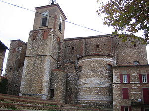
 Notre-Dame de la Victoire church |
||
Thuir ( Tuïr in Catalan ) is a French commune with 7635 inhabitants (as of January 1, 2017) in the Pyrénées-Orientales department in the Occitania region .
Thuir is located in the Roussillon plain , about 13 kilometers southwest of Perpignan at the foot of the Pyrenees .
The place is known beyond the borders of France for the production of the aperitif Byrrh , which was invented here in the 19th century.
Personalities
- Angélique Duchemin (1991-2017), boxer
Web links
Commons : Thuir - collection of images, videos and audio files
