
Saint-André (Pyrénées-Orientales)
|
Saint-André Sant Andreu de Sureda |
||
|---|---|---|

|
|
|
| region | Occitania | |
| Department | Pyrénées-Orientales | |
| Arrondissement | Ceret | |
| Canton | La Cote Vermeille | |
| Community association | Albères, Côte Vermeille et l'Illibéris | |
| Coordinates | 42 ° 33 ' N , 2 ° 58' E | |
| height | 13-77 m | |
| surface | 9.73 km 2 | |
| Residents | 3,443 (January 1, 2017) | |
| Population density | 354 inhabitants / km 2 | |
| Post Code | 66690 | |
| INSEE code | 66168 | |
| Website | http://www.saint-andre66.fr | |

Saint-André ( Catalan Sant Andreu de Sureda ) is a French commune with 3443 inhabitants (as of January 1, 2017) in the Pyrénées-Orientales department in the Occitania region . It belongs to the Arrondissement of Céret and the canton of La Côte Vermeille .
politics
mayor
| Surname | Term of office |
|---|---|
| Joseph Bourrat | 1944-1945 |
| René Tasque | 1945-1947 |
| Henri Bagnouls | 1947-1977 |
| Francis Manent | 1977– |
Parish partnership
Saint-André is connected to the German community of Eichstetten am Kaiserstuhl in Baden-Württemberg through a community partnership.
Population development
| year | 1962 | 1968 | 1975 | 1982 | 1990 | 1999 | 2006 | 2007 |
|---|---|---|---|---|---|---|---|---|
| Residents | 834 | 843 | 1,016 | 1,718 | 2.123 | 2,519 | 2.712 | 2,717 |
Attractions
- The three -apse church of St-André-de-Sorède , the only surviving structure of the Saint-André abbey (10th century), is a monument historique .
- Saint-André
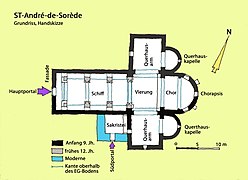
Floor plan, hand sketch

Choir head from the southeast

Lintel and tympanum
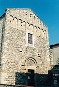
Facade from the northwest

Islamic tombstone

Facade window


Web links
Commons : Saint-André - Collection of images, videos and audio files