Alénya
|
Alénya Alenyà |
||
|---|---|---|

|
|
|
| region | Occitania | |
| Department | Pyrénées-Orientales | |
| Arrondissement | Ceret | |
| Canton | La Plaine d'Illibéris | |
| Community association | South Roussillon | |
| Coordinates | 42 ° 38 ′ N , 2 ° 59 ′ E | |
| height | 3-18 m | |
| surface | 5.34 km 2 | |
| Residents | 3,601 (January 1, 2017) | |
| Population density | 674 inhabitants / km 2 | |
| Post Code | 66200 | |
| INSEE code | 66002 | |
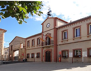
 Mairie Alénya |
||
Alénya ( Catalan Alenyà ) is a French commune with 3601 inhabitants (as of January 1, 2017) in the Pyrénées-Orientales department of the Occitania region . The place belongs to the Arrondissement of Céret and the canton of La Plaine d'Illibéris .
geography
Alénya is three and a half kilometers from the Étang de Canet-Saint-Nazaire , four kilometers from the Mediterranean Sea , seven kilometers from Canet-en-Roussillon , four kilometers from Saint-Cyprien , ten kilometers from Perpignan and 25 kilometers from the Spanish border. The holy mountain of the Catalans , the Pic du Canigou , is about 40 kilometers away.
Neighboring municipalities are Saint-Nazaire , Canet-en-Roussillon , Saint-Cyprien , Elne , Corneilla-del-Vercol , Théza , Saleilles .
The village is surrounded by vineyards, apricot and peach plantations.
Population development
| year | 1962 | 1968 | 1975 | 1982 | 1990 | 1999 | 2008 | 2017 |
| Residents | 695 | 678 | 1006 | 1211 | 1562 | 2318 | 2912 | 3601 |
| Sources: Cassini and INSEE | ||||||||
