
Pic du Canigou
| Pic du Canigou | ||
|---|---|---|
 View of the Canigou |
||
| height | 2785 m | |
| location | Pyrénées-Orientales , France | |
| Mountains | Pyrenees | |
| Coordinates | 42 ° 31 '0 " N , 2 ° 27' 37" E | |
|
||

The Pic du Canigou ( catal .: Pic del Canigó ) is the most easterly prominent mountain peak of the Pyrenees . It has a height of 2785 m and has long been considered the highest mountain in Catalonia . It belongs to the southern French department Pyrénées-Orientales in Roussillon . The closest larger town is Perpignan , about 50 km east of the mountain.
The two important medieval abbeys of Saint-Martin-du-Canigou and Saint-Michel-de-Cuxa are located on the slopes of the Pic du Canigou .
meaning
The slopes of the Canigou, which are often snowed into the summer, are visible from afar from the coastal plain of the Mediterranean Sea and can still be seen 100 kilometers beyond the coastline. This may have contributed to the fact that the Canigou became a symbolic mountain for Catalonia and Northern Catalonia and is sometimes still regarded today as the “Holy Mountain” or “Olympus” of the Catalans. The Catalan flag with multiple yellow and red stripes usually flies at the summit .
tradition
On the night of June 23rd to 24th ( St. John's Day ) a fire is lit on the summit of Canigou. Towards morning, the mostly young participants bring burning torches to the villages in the valley.
history
The mountain is first mentioned in Latin written documents from the year 949 as Montis Canigonis . Around the year 1300 the Catalan spelling canigó is found for the first time . In 1285 the mountain is said to have been owned by the Aragonese King Peter III. have been climbed. But the king did not get to the summit, because a fire-breathing dragon rose from a lake there.
The top of the mountain, which was considered the highest of the Pyrenees at the time, was the southernmost point of measurement of the meridian of Paris carried out in 1700 by Jean-Dominique Cassini (Cassini I) and his son Jacques Cassini (Cassini II) . A stone pyramid was erected on the summit, so that employees of the Cassini, if not the son himself, may have been the first to climb the Pic de Canigou.
climate
The Pic du Canigou has several climate zones. Up to an altitude of 800 to 1000 m one speaks of a Mediterranean climate, then up to around 1700 m of a mountain climate. Up to about 2300 m the climate is subalpine; the top of the mountain belongs to the alpine mountain zone.
Ascent

The summit region of the Canigou can be climbed with good footwear and in good physical condition during a day tour over several paths. There is also the option of covering most of the ascent with the help of booked places in an all-terrain jeep and only having to climb the last 600 meters in about two hours on foot.
gallery
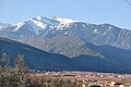
View over Vinça to the Pic du Canigou

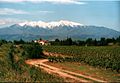
Flowering peach trees in the valley of the Têt against the backdrop of the Canigou
The Canigou from Perpignan seen from


Web links
- Pic du Canigou - photos and maps
- Pic du Canigou - ascent and photo links
- Pic du Canigou - ascent and photos
Individual evidence
- ↑ El Canigó ja no es diu Canigou. Vilaweb (Internet magazine), July 15, 2012, archived from the original on July 17, 2012 ; Retrieved February 3, 2015 (Catalan).
- ↑ De la grandeur et de la figure de la terre . In: Academie Royale des Sciences (ed.): Suite des Memoires de l'Academie Royale des Sciences . Imprimerie Royale, Paris 1720, doi : 10.3931 / e-rara-516 (306 pp.).