
Bélesta (Pyrénées-Orientales)
|
Bélesta Belestarr |
||
|---|---|---|
.svg)
|
|
|
| region | Occitania | |
| Department | Pyrénées-Orientales | |
| Arrondissement | Prades | |
| Canton | La Vallée de l'Agly | |
| Community association | Roussillon-Conflent | |
| Coordinates | 42 ° 43 ' N , 2 ° 36' E | |
| height | 122-561 m | |
| surface | 20.52 km 2 | |
| Residents | 221 (January 1, 2017) | |
| Population density | 11 inhabitants / km 2 | |
| Post Code | 66720 | |
| INSEE code | 66019 | |
| Website | http://www.belesta.fr/ | |
.jpg) View of Bélesta |
||

Bélesta ( Occitan : Belhestar ) is a municipality with 221 inhabitants (as of January 1, 2017) in the Pyrénées-Orientales department in the Occitania region of southern France . Estagel belongs to the Arrondissement of Prades and the canton of La Vallée de l'Agly (until 2015: canton of Latour-de-France ). The inhabitants are called Ballestrucs .
geography
Bélesta is about 20 kilometers west-northwest of Perpignan . Bélesta is surrounded by the neighboring communities of Cassagnes in the north, Montner in the north-east, Millas in the east and south-east, Néfiach in the south-east, Ille-sur-Têt in the south, Montalba-le-Château in the west and south-west and Caramany in the north-west.
Population development
| year | 1962 | 1968 | 1975 | 1982 | 1990 | 1999 | 2006 | 2012 |
| Residents | 318 | 312 | 262 | 247 | 223 | 215 | 214 | 225 |
| Source: Cassini and INSEE | ||||||||
economy
As in the neighboring communities, viticulture plays a particularly important role. The municipality belongs to the wine-growing regions of Côtes du Roussillon-Villages and Rivesaltes .
Attractions
- Saint-Barthélemy church in Bélesta, Romanesque church building
- Ruins of the Saint-Barthélemy church in Jonquerolles, pre- or early Romanesque church ruins
- Dolmen du Molí del Vent
- Llebres ruins
- Attractions
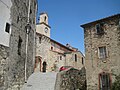
Saint Barthélemy Church in Bélesta
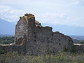
Ruins of the Saint-Barthélemy church in Jonquerolles

Dolmen of Bélesta

Llébrès ruins


Personalities
- François Arago (1786–1853), astronomer and politician
- Jacques Arago (1790-1854), writer