
Bouleternère
| Bouleternère | ||
|---|---|---|

|
|
|
| region | Occitania | |
| Department | Pyrénées-Orientales | |
| Arrondissement | Prades | |
| Canton | Le Canigou | |
| Community association | Roussillon-Conflent | |
| Coordinates | 42 ° 39 ′ N , 2 ° 35 ′ E | |
| height | 160-612 m | |
| surface | 10.63 km 2 | |
| Residents | 935 (January 1, 2017) | |
| Population density | 88 inhabitants / km 2 | |
| Post Code | 66130 | |
| INSEE code | 66023 | |
| Website | http://www.bouleternere.fr/ | |
 Saint-Sulpice church |
||

Bouleternère is a French commune with 935 inhabitants (as of January 1, 2017) in the Pyrénées-Orientales department in the Occitania region . It belongs to the Arrondissement of Prades and the canton of Le Canigou .
geography
Neighboring municipalities of Bouleternère are Ille-sur-Têt in the northeast, Saint-Michel-de-Llotes in the east, Casefabre in the southeast, Boule-d'Amont in the south and Rodès in the northwest.

Population development
| year | 1962 | 1968 | 1975 | 1982 | 1990 | 1999 | 2013 |
| Residents | 818 | 885 | 739 | 728 | 625 | 643 | 906 |
Attractions
- City wall with two towers and three gates
- Chapel of Sainte-Anne
- Saint Nazaire Church in Barbadell
- Former Saint-Sulpice church (11th century)
- New Saint-Sulpice Church (1659)
- Belpuig Castle (14th century)
- Saint-Etienne church in Prunet
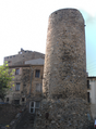
Tower of the city wall

Tower of the city wall

Portal of the new Saint-Sulpice church

Saint Nazaire Church in Barbadell


Web links
Commons : Bouleternère - collection of images, videos and audio files