
Angoustrine-Villeneuve-des-Escaldes
| Angoustrine-Villeneuve-des-Escaldes | ||
|---|---|---|
|
||
| region | Occitania | |
| Department | Pyrénées-Orientales | |
| Arrondissement | Prades | |
| Canton | Les Pyrénées Catalanes | |
| Community association | Pyrénées Cerdagne | |
| Coordinates | 42 ° 29 ′ N , 1 ° 57 ′ E | |
| height | 1,235-2,921 m | |
| surface | 87.87 km 2 | |
| Residents | 608 (January 1, 2017) | |
| Population density | 7 inhabitants / km 2 | |
| Post Code | 66760 | |
| INSEE code | 66005 | |
| Website | http://www.angoustrine.net/ | |
 Town hall (Mairie) of Angoustrine-Villeneuve-des-Escaldes |
||

Angoustrine-Villeneuve-des-Escaldes ( Catalan : Angostrina i Vilanova de les Escaldes ) is a French commune with 608 inhabitants (as of January 1, 2017) in the Pyrénées-Orientales department in the Occitania region . The municipality belongs to the Prades arrondissement and the canton of Les Pyrénées catalanes (until 2015: Saillagouse canton ). The inhabitants are called Angoustrinois .
geography
Angoustrine-Villeneuve-des-Escaldes is located in the Cerdanya in the Pyrenees near the border with Spain . In the municipal area is the Pic Carlit at 2,921 meters and the Bouillouses lake , which drains into the Têt . Angoustrine-Villeneuve-des-Escaldes is surrounded by the neighboring municipalities of Orlu in the north, Formiguères in the northeast, Les Angles and Bolquère in the east, Font-Romeu-Odeillo-Via and Targassonne in the east and southeast, the Spanish exclave Llívia and Ur in the south, Dorres in the southwest, Porté-Puymorens in the west and Mérens-les-Vals in the northwest.
history
In 1973 the municipalities of Angoustrine and Villeneuve-des-Escaldes were merged.
Population development
| year | 1962 | 1968 | 1975 | 1982 | 1990 | 1999 | 2006 | 2013 |
| Residents | 223 | 218 | 573 | 556 | 600 | 549 | 632 | 714 |
| Source: Cassini and INSEE | ||||||||
Attractions
- old Saint-André church from the 12th century
- Saint-André church in Angoustrine
- Saint-Assiscle-et-Sainte-Victoire church in Villeneuve-des-Escaldes
- Saint-Martin chapel

Old Saint-André church
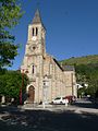
Saint-André church

Saint-Assiscle-et-Sainte-Victoire church

Saint-Martin chapel


