
Lavardens
| Lavardens | ||
|---|---|---|
.svg)
|
|
|
| region | Occitania | |
| Department | Gers | |
| Arrondissement | Also | |
| Canton | Gascony Auscitaine | |
| Community association | Grand Auch Cœur de Gascogne | |
| Coordinates | 43 ° 46 ' N , 0 ° 31' E | |
| height | 126–245 m | |
| surface | 30.55 km 2 | |
| Residents | 385 (January 1, 2017) | |
| Population density | 13 inhabitants / km 2 | |
| Post Code | 32360 | |
| INSEE code | 32204 | |
 View of Lavardens |
||

Lavardens ( Gascon identical) is a French municipality with 385 inhabitants (at January 1, 2017) in the department of Gers in the region Occitania (before 2016 Midi-Pyrenees ). It belongs to the arrondissement Auch and the canton Gascogne-Auscitaine ( Jegun until 2015 ). Lavardens is also a member of the Grand Auch Cœur de Gascogne community association founded in 2001 .
location
Lavardens is located about seventy kilometers west-northwest of Toulouse on the Ruisseau de Lahontan river , a tributary of the Loustère , which is still called the Guzerde here in the upper reaches . Lavardens is surrounded by the neighboring communities of Cézan in the north, Préchac in the northeast, Puységur and Roquefort in the east, Mérens in the east and southeast, Peyrusse-Massas in the southeast, Castillon-Massas and Saint-Lary in the south and Jegun in the west.
history
Lavardens fortress was the military heart of Armagnac in the late 12th century . In 1496 the fortress was razed after the battle or siege of Lavardens. The present castle in the form of a castle was built around 1620.
Population development
| year | 1800 | 1831 | 1881 | 1911 | 1921 | 1962 | 1968 | 1975 | 1982 | 1990 | 1999 | 2006 | 2011 | 2016 | |
| Residents | 1,245 | 1,408 | 1,030 | 758 | 709 | 517 | 504 | 422 | 373 | 377 | 378 | 372 | 405 | 393 | |
| Sources: Cassini and INSEE; today's municipal area | |||||||||||||||
Attractions
- Saint-Michel church from the 15th century, monument historique since 1960
- Castle or castle Lavardens from the 17th century, since 1961 Monument historique

Saint-Michel church
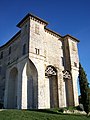
Lavardens Castle / Castle

