Polastron (Gers)
| Polastron | ||
|---|---|---|
|
|
||
| region | Occitania | |
| Department | Gers | |
| Arrondissement | Also | |
| Canton | Val de Save | |
| Community association | Le Savès | |
| Coordinates | 43 ° 32 ' N , 0 ° 51' E | |
| height | 171-286 m | |
| surface | 15.21 km 2 | |
| Residents | 272 (January 1, 2017) | |
| Population density | 18 inhabitants / km 2 | |
| Post Code | 32130 | |
| INSEE code | 32321 | |
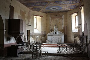
 Interior of the Saint-Pierre church |
||
Polastron ( Gaskognisch : identical) is a French commune with 272 inhabitants (as of January 1, 2017) in the Gers department in the Occitania region . It belongs to the canton of Val de Save and the arrondissement of Auch . The inhabitants are called Polastronnais .
location
Polastron is about 53 kilometers west-southwest of Toulouse . Polastron is surrounded by the neighboring municipalities of Aurimont and Saint-André in the north, Bézéril in the east and north-east, Saint-Soulan in the south and south-east, Saint-Martin-Gimois in the south and south-west and Tirent-Pontéjac in the west and north-west.
Population development
| year | 1962 | 1968 | 1975 | 1982 | 1990 | 1999 | 2006 | 2017 | |
|---|---|---|---|---|---|---|---|---|---|
| Residents | 302 | 231 | 198 | 191 | 191 | 188 | 230 | 272 | |
| Sources: Cassini and INSEE | |||||||||
Attractions
- Polastron Church from the 15th century
- Saint-Pierre church of Laurac
- Castle ruins
Web links
Commons : Polastron - collection of images, videos and audio files
