Aubiet
| Aubiet | ||
|---|---|---|

|
|
|
| region | Occitania | |
| Department | Gers | |
| Arrondissement | Also | |
| Canton | Also-2 | |
| Community association | Coteaux Arrats Gimone | |
| Coordinates | 43 ° 39 ' N , 0 ° 47' E | |
| height | 138-233 m | |
| surface | 38.96 km 2 | |
| Residents | 1,083 (January 1, 2017) | |
| Population density | 28 inhabitants / km 2 | |
| Post Code | 32270 | |
| INSEE code | 32012 | |
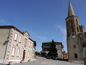
 Mairie and Saints-Abdon-et-Sernnen church |
||
Aubiet is a French commune with 1,083 inhabitants (as of January 1, 2017) in the Gers department in the Occitania region of southern France (previously Midi-Pyrénées ). Historically, the place belongs to the former province of Gascogne and the former vice-county of Fézensaguet . Today the municipality is part of the arrondissement of Auch and the canton of Auch-2 (previously Gimont ).
geography
Aubiet is about 16 kilometers west of Auch and on the southernmost part of the Way of St. James , the Via Tolosana . The national route 124 and the railway line from Saint-Agne to Auch (with a train station in Aubiet) run through the municipality .
history
Aubiet was founded in the 10th or 11th century.
Population development
| year | 1968 | 1975 | 1982 | 1990 | 1999 | 2006 | 2017 |
| Residents | 971 | 880 | 911 | 1019 | 1001 | 1059 | 1083 |
Personalities
- Jean-Luc Lagardère (1928–2003), entrepreneur
- François Alem Rousseau (1793–1868), politician
Web links
Commons : Aubiet - collection of images, videos and audio files
