
Saint-Sauvy
|
Saint-Sauvy Sent Sauvi |
||
|---|---|---|
.svg)
|
|
|
| region | Occitania | |
| Department | Gers | |
| Arrondissement | Also | |
| Canton | Gimone Arrats | |
| Community association | Coteaux Arrats Gimone | |
| Coordinates | 43 ° 42 ' N , 0 ° 49' E | |
| height | 132-220 m | |
| surface | 17.58 km 2 | |
| Residents | 340 (January 1, 2017) | |
| Population density | 19 inhabitants / km 2 | |
| Post Code | 32270 | |
| INSEE code | 32406 | |
 Town hall (Mairie) of Saint-Sauvy |
||

Saint-Sauvy ( Gascon Sent Sauvi ) is a French municipality with 340 inhabitants (at January 1, 2017) in the department of Gers in the region Occitania (before 2016 Midi-Pyrenees ). It belongs to the arrondissement Auch and the canton Gimone-Arrats (until 2015 Gimont ). The inhabitants are called Saint-Sauviens .
geography
Saint-Sauvy is about fifty kilometers west-northwest of Toulouse . Neighboring municipalities are Saint-Antonin in the north, Mauvezin in the northeast, Sainte-Marie in the east and southeast, Blanquefort in the south, Ansan in the south and southwest, Crastes in the west and Augnax in the northwest.
Population development
| year | 1962 | 1968 | 1975 | 1982 | 1990 | 1999 | 2006 | 2011 | 2016 |
|---|---|---|---|---|---|---|---|---|---|
| Residents | 458 | 390 | 336 | 306 | 319 | 331 | 314 | 369 | 332 |
| Source: Cassini and INSEE | |||||||||
Attractions
- Saint-Salvy church from the 14th century
- Lucvielle Church
- 19th century castle
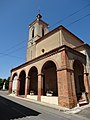
Saint-Salvy church
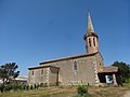
Lucvielle Church


Web links
Commons : Saint-Sauvy - collection of images, videos and audio files