
Preignan
|
Preignan Prenhan |
||
|---|---|---|
.svg)
|
|
|
| region | Occitania | |
| Department | Gers | |
| Arrondissement | Also | |
| Canton | Gascogne-Auscitaine (main town) | |
| Community association | Grand Auch Cœur de Gascogne | |
| Coordinates | 43 ° 43 ' N , 0 ° 38' E | |
| height | 112-197 m | |
| surface | 10.67 km 2 | |
| Residents | 1,276 (January 1, 2017) | |
| Population density | 120 inhabitants / km 2 | |
| Post Code | 32810 | |
| INSEE code | 32331 | |
| Website | http://www.preignan.fr/ | |
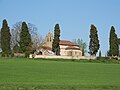
 View of Preignan |
||

Preignan ( Gaskognisch Prenhan ) is a French commune with 1,276 inhabitants (as of January 1, 2017) in the Gers department in the Occitania region (before 2016 Midi-Pyrénées ). It belongs to the arrondissement Auch and the canton Gascogne-Auscitaine (until 2015 Auch-Nord-Ouest ). Preignan is also a member of the Grand Auch Cœur de Gascogne community association founded in 2001 .
location
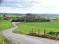
Preignan is located about nine kilometers north-northeast of Auch in the center of the Gers department, on the Gers river , near the confluence of its tributary Arçon . Preignan is surrounded by the neighboring communities of Sainte-Christie in the north, Mirepoix in the northeast, Montaut-les-Créneaux in the south and east, Auch in the south and southwest and Roquelaure in the west.
Population development
| year | 1793 | 1800 | 1831 | 1881 | 1911 | 1921 | 1962 | 1968 | 1975 | 1982 | 1990 | 1999 | 2006 | 2017 |
| Residents | 232 | 192 | 346 | 255 | 223 | 190 | 188 | 183 | 312 | 499 | 793 | 961 | 1015 | 1276 |
| Sources: Cassini and INSEE; today's municipal area | ||||||||||||||
Attractions
- Romanesque church of Saint-Étienne from the 16th century
- Charterhouse of Pastissé
- Preignan castle ruins
Saint-Etienne church
Charterhouse of Pastissé

Preignan castle ruins


Community partnerships
Partnerships have existed with the Spanish municipality of Corral de Calatrava in the Castile-La Mancha region since 1997 and with the French municipality of Vic-Fezensac in the Gers department since 2009.