
Saint-Caprais (Gers)
|
Saint-Caprais Sent Cabrari |
||
|---|---|---|
|
||
| region | Occitania | |
| Department | Gers | |
| Arrondissement | Also | |
| Canton | Also-2 | |
| Community association | Coteaux Arrats Gimone | |
| Coordinates | 43 ° 36 ' N , 0 ° 47' E | |
| height | 155-237 m | |
| surface | 7.89 km 2 | |
| Residents | 139 (January 1, 2017) | |
| Population density | 18 inhabitants / km 2 | |
| Post Code | 32200 | |
| INSEE code | 32467 | |
| Website | http://saint-caprais32.blogspot.ch/ | |
_2.jpg) Mairie Saint-Caprais |
||

Saint-Caprais ( Gascon Sent Cabrari ) is a French municipality with 139 inhabitants (at January 1, 2017) in the department of Gers in the region Okzitanien ; it belongs to the arrondissement Auch and the municipality association Coteaux Arrats Gimone . Its inhabitants call themselves Saint-Capraisiens / Saint-Capraisiennes .
geography
Saint-Caprais is located around 17 kilometers east-southeast of the city. Also in the southeast of the Gers department. The community consists of the village of Saint-Caprais, several groups of houses and individual farmsteads. The Arrats forms the western and the Gimone the eastern municipal boundary . In terms of traffic, the community is a few kilometers south of the N124 .
history
In the Middle Ages, the place was within the county of Astarac, which was part of the province of Gascony. In 1947, Saint-Caprais split from the municipality of Juilles and belonged to the canton of Gimont from 1947 to 2015 . The community has been assigned to the arrondissement Auch since 1947.
Population development
| year | 1954 | 1962 | 1968 | 1975 | 1982 | 1990 | 1999 | 2006 | 2017 |
| Residents | 158 | 145 | 119 | 104 | 106 | 101 | 102 | 112 | 139 |
| Sources: Cassini and INSEE | |||||||||
Attractions
- Saint-Caprais village church
- Saint Roch chapel
- Commemorative plaque for the fallen
- several wayside crosses and a statue of the Madonna

Saint-Caprais church
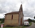
Saint Roch chapel
_4.jpg)
_10.jpg)
Web links
- Location of the place in France
- Saint-Caprais village church
- Brief information about the municipality (French)