
Roquelaure
|
Roquelaure Ròcalaura |
||
|---|---|---|
|
||
| region | Occitania | |
| Department | Gers | |
| Arrondissement | Also | |
| Canton | Gascony Auscitaine | |
| Community association | Grand Auch Cœur de Gascogne | |
| Coordinates | 43 ° 43 ' N , 0 ° 35' E | |
| height | 106-239 m | |
| surface | 21.23 km 2 | |
| Residents | 572 (January 1, 2017) | |
| Population density | 27 inhabitants / km 2 | |
| Post Code | 32810 | |
| INSEE code | 32348 | |
 View of Roquelaure |
||

Roquelaure ( Gaskognisch Ròcalaura ) is a French commune with 572 inhabitants (as of January 1, 2017) in the Gers department in the Occitania region (before 2016 Midi-Pyrénées ). It belongs to the arrondissement Auch and the canton Gascogne-Auscitaine (until 2015 Auch-Nord-Ouest ). Roquelaure is also a member of the Grand Auch Cœur de Gascogne community association founded in 2001 . The inhabitants are called Roquelaurais (es) .
location
Roquelaure is about eight kilometers north-northwest of the city of Auch . Roquelaure is surrounded by the neighboring communities of Roquefort in the north, Sainte-Christie in the north-east, Preignan in the east, Auch in the south, Castillon-Massas in the west and south-west and Peyrusse-Massas in the north-west.
Population development
| year | 1800 | 1831 | 1881 | 1911 | 1921 | 1962 | 1968 | 1975 | 1982 | 1990 | 1999 | 2006 | 2011 | 2016 | |
| Residents | 756 | 820 | 635 | 544 | 446 | 432 | 424 | 338 | 392 | 464 | 454 | 515 | 589 | 577 | |
| Sources: Cassini and INSEE; today's municipal area | |||||||||||||||
Attractions
- Saint-Loup church
- 13th century Saint Blaise chapel in Arcamont
- Le Rieufort Castle
- Arcamont tower

Saint Blaise Chapel
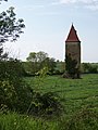
Arcamont Tower


Personalities
- Antoine de Roquelaure (1543–1625), Marshal of France