
Montégut (Gers)
|
Montégut Montagut |
||
|---|---|---|
|
||
| region | Occitania | |
| Department | Gers | |
| Arrondissement | Also | |
| Canton | Also-2 | |
| Community association | Grand Auch Cœur de Gascogne | |
| Coordinates | 43 ° 39 ′ N , 0 ° 39 ′ E | |
| height | 135-257 m | |
| surface | 11.42 km 2 | |
| Residents | 667 (January 1, 2017) | |
| Population density | 58 inhabitants / km 2 | |
| Post Code | 32550 | |
| INSEE code | 32282 | |
 View of Montégut |
||

Montégut ( Gaskognisch Montagut ) is a French commune with 667 inhabitants (as of January 1, 2017) in the Gers department in the Occitanie region ; it belongs to the arrondissement Auch and the municipality of Grand Auch Cœur de Gascogne . Its inhabitants call themselves Montégutois / Montégutoises .
geography
Montégut is located on a hill about five kilometers east of the city Auch in the center of the Gers department. The river Arçon crosses the west of the municipality and in parts forms the western municipal boundary. Another stream, the Ruisseau de Larroussagnet , marks in parts the northern border of the municipality. The community consists of the village of Montégut and numerous hamlets and farmhouses. In terms of traffic, the community is less than 1 kilometer south of the N124 .
To the east of the village is Le Monastère (the monastery) with the village cemetery and the former monastery chapel. A pediatric center for the Order of Malta is located in the Château de Roquetaillade in the southeast of the municipality . The place is on Via Tolosana , one of the pilgrimage routes to Santiago de Compostela.
history
The original name Monte Accuto indicates a Gallo-Roman or Roman settlement. The first fortress was built in the 13th century. The fortified town of Montégut was close by. In the Middle Ages, the place was within the county of Haut-Armagnac, which was part of the province of Gascogne. The community belonged to the District of Auch from 1793 to 1801. In addition, Montégut was part of the canton of Barran from 1793 to 1801. From 1801 to 1973 it was in the canton of Auch-Nord. Then from 1973 to 2015 within the canton of Auch-Nord-Est . The municipality has been assigned to the arrondissement Auch since 1801. In 1821 the previous municipality of Roquetaillade (1821: 117 inhabitants) came to Montégut.
Population development
| year | 1793 | 1800 | 1806 | 1821 | 1921 | 1962 | 1968 | 1975 | 1982 | 1990 | 1999 | 2006 | 2014 |
| Residents | 357 | 376 | 348 | 383 | 186 | 182 | 191 | 234 | 311 | 317 | 397 | 462 | 647 |
| Sources: Cassini and INSEE; today's municipal area | |||||||||||||
Attractions
- Castle Château de Montégut in the west of the village
- Castle Château de Roquetaillade in the southeast of the community
- Notre-Dame-de-l'Assomption village church in Montégut
- Saint-Jacques Chapel in Roquetaillade
- Friedhofskapelle (former monastery chapel)
- Memorial to the Fallen
- Tour des Fées ruins (Tower of the Fairies) in the Bois des Fées forest east of the village
- Crossroads in L'Arramont and La Ramon
- Dovecote

Castle of Montégut

Notre-Dame-de-l'Assomption village church

Saint-Jacques Chapel in Roquetaillade

Dovecote
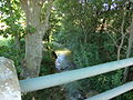
The brook Arçon
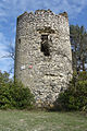
Ruin of the Tower of the Fairies
_ch%C3%A2teau.JPG)

_chapelle_%C3%A0_Roquetaillade.JPG)
_pigeonnier.JPG)
_l%27Ar%C3%A7on.JPG)

Web links
- Location of the place in France
- Montégut on the IGN side
- Village church and chapels
- Brief information about the municipality (French)