
Belmont (Gers)
|
Belmont Bèlmont |
||
|---|---|---|
|
||
| region | Occitania | |
| Department | Gers | |
| Arrondissement | Also | |
| Canton | Fezensac | |
| Community association | Artagnan de Fezensac | |
| Coordinates | 43 ° 41 ′ N , 0 ° 14 ′ E | |
| height | 130-2,121 m | |
| surface | 15.10 km 2 | |
| Residents | 150 (January 1, 2017) | |
| Population density | 10 inhabitants / km 2 | |
| Post Code | 32190 | |
| INSEE code | 32043 | |
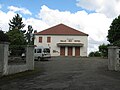
 Town hall (Mairie) of the municipality |
||

Belmont ( Gaskognisch Bèlmont ) is a French commune with 150 inhabitants (as of January 1, 2017) in the Gers department in the Occitanie region (until 2015 Midi-Pyrénées ); it belongs to the arrondissement Auch and to the community association Artagnan de Fezensac . The residents call themselves Belmontais / Belmontaises .
geography
Belmont is located around 28 kilometers west-northwest of Auch in the center of the Gers department. The community consists of numerous scattered settlements and individual farmsteads. The Guiroue forms the eastern municipal border in parts. In addition, the Auzoue (still called Lauzoue here) crosses the municipality in a northerly direction and in parts forms the western municipality boundary.
Neighboring communities are Préneron in the north, Roquebrune and Tudelle in the east, Cazaux-d'Anglès in the south-east and south, Montesquiou in the south-west, Lupiac in the west and Castillon-Debats in the north-west.
history
In the Middle Ages, Belmont was in the county of Vic-Fezensac within the Armagnac region in the historic Gascony region and shared its fate. Belmont belonged to the District of Auch from 1793 to 1801. Belmont has been part of the Arrondissement Auch since 1801 and belonged to the Vic-Fezensac canton (originally called Vic-sur-Losse canton) from 1793 to 2015 . The municipality has only existed in its current form since 1821. At that time, the former municipality of Belmont (1821: 526 inhabitants) merged with the municipality of Castera-Preneron (1821: 96 inhabitants) to form today's municipality.
Population development
The population development is typical for a French rural community. The developments between 1793 and 1821 with strong growth and the subsequent strong rural exodus from 1856 to 1921 are normal. After a short growth phase, a second wave of emigration began from 1931 until 1991. Since then, the population has stabilized at around 150 people.
| year | 1793 | 1800 | 1821 | 1856 | 1921 | 1931 | 1962 | 1968 | 1975 | 1982 | 1990 | 1999 | 2006 | 2011 | 2017 |
| Residents | 531 | 509 | 622 | 595 | 322 | 362 | 258 | 246 | 225 | 191 | 165 | 150 | 150 | 151 | 150 |
| Sources: Cassini, Belmont Cassini, Castera-Preneron and INSEE ; From 1793 to 1821, the municipality is already today | |||||||||||||||
Attractions
- Village church Église de l'Assomption
- a total of four wayside crosses
- Memorial to the Fallen

Village church Église de l'Assomption

Memorial to the Fallen
Banquet hall of the community

former market hall


traffic
The community is not on national traffic routes and has no rail or bus connections. Important regional traffic routes are the D1 (to the north and south), the D37 (to the west) and the D174 (to the east). The most important national traffic connection is the N124 with a connection in Vic-Fezensac.
Web links
- Belmont on the IGN side
- Village church Église de l'Assomption
- Location of the place and brief information
- Sights of Belmont on Le Patrimoine rural du Gers