Ayguetin ink
|
Ayguetinte Aigatinta |
||
|---|---|---|
|
|
||
| region | Occitania | |
| Department | Gers | |
| Arrondissement | Also | |
| Canton | Baïse-Armagnac | |
| Community association | Grand Auch Cœur de Gascogne | |
| Coordinates | 43 ° 50 ' N , 0 ° 26' E | |
| height | 96-203 m | |
| surface | 6.31 km 2 | |
| Residents | 161 (January 1, 2017) | |
| Population density | 26 inhabitants / km 2 | |
| Post Code | 32410 | |
| INSEE code | 32024 | |
Ayguetinte ( Occitan : Aigatinta ) is a municipality with 161 inhabitants (as of January 1, 2017) in France in the Gers department , in the Occitanie region . The municipality belongs to the canton of Baïse-Armagnac and was part of the canton of Valence-sur-Baïse until 2015 . The inhabitants are called Aigantintiens .
geography
Ayguetinte is located about 25 kilometers north-northwest of Auch an der Auloue , which borders the municipality in the east. Ayguetinte is surrounded by the neighboring communities of Valence-sur-Baïse in the north and north-west, Saint-Puy in the north-east, Larroque-Saint-Sernin in the east, Castéra-Verduzan in the south and Beaucaire in the west.
history
| Population development | |||||||||
|---|---|---|---|---|---|---|---|---|---|
| year | 1962 | 1968 | 1975 | 1982 | 1990 | 1999 | 2006 | 2011 | 2016 |
| Residents | 222 | 199 | 173 | 172 | 162 | 152 | 175 | 190 | 161 |
| Source: Cassini and INSEE | |||||||||
Attractions
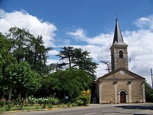
- Church of Sainte-Radegonde
- Mill
- Fortified house
Personalities
- Joseph Raulin (1708–1784), physician (gynecologist)
Web links
Commons : Ayguetinte - collection of images, videos and audio files

