
Pébées
|
Pébées Pebeas |
||
|---|---|---|
|
||
| region | Occitania | |
| Department | Gers | |
| Arrondissement | Also | |
| Canton | Val de Save | |
| Community association | Savès | |
| Coordinates | 43 ° 28 ′ N , 1 ° 2 ′ E | |
| height | 198-315 m | |
| surface | 4.05 km 2 | |
| Residents | 103 (January 1, 2017) | |
| Population density | 25 inhabitants / km 2 | |
| Post Code | 32130 | |
| INSEE code | 32308 | |
 Mairie Pébées |
||

Pébées ( Occitan : Pebeas , between 1793 and 1801 also with the spellings Pebées, Pebecs and Pébées ) is a French commune with 103 inhabitants (as of January 1, 2017) in the Gers department in the Occitania region (until 2015 Midi-Pyrénées ). It belongs to the arrondissement Auch and to the Savès community association founded in 2002 . The inhabitants call themselves Pébésiens .
geography
Pébées is located in an agriculturally intensively used area in the east of the Gers department on the border with the Haute-Garonne department , 38 kilometers southwest of Toulouse . The upper reaches of the Boulouze flows through the municipality of Pébées . The almost 20 kilometers long Boulouze is a tributary of the Save in the catchment area of the Garonne . The almost forest-free 4.05 km² community area is characterized by fields and pastures. The ground relief is lively: while the Mairie of the municipality is 217 m above sea level, the highest point is reached in the extreme south at 315 m. The largest of the numerous hamlets are La Roque de Bas, Pétrille, La Borde Neuve, Le Serre de Haut and La Bourdette . Pébées is bordered by the neighboring municipalities of Sabonnères in the northeast, Montgras in the east, Lahage in the southeast, Saint-Loube in the south, Monblanc in the west and Savignac-Mona in the northwest.
Population development
| year | 1962 | 1968 | 1975 | 1982 | 1990 | 1999 | 2007 | 2017 |
|---|---|---|---|---|---|---|---|---|
| Residents | 74 | 63 | 46 | 68 | 66 | 67 | 91 | 133 |
| Sources: Cassini and INSEE | ||||||||
Attractions
- Saint-Hippolyte church from the 16th century, monument historique
- Lavoir
- Virgin Mary statue
- several wayside crosses

Virgin Mary statue 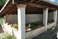
Lavoir


Economy and Infrastructure
There are eight farms in the municipality of Pébées (cereal and vegetable growing, dairy farming, goat and sheep breeding).
The D119 / D28 trunk road from Samatan to Rieumes runs through the south of the municipality of Pébées . In Longages , 24 kilometers away, there is a connection to the A 64 autoroute . There is also a train station on the Toulouse – Bayonne railway line here .
supporting documents
- ↑ toponym on cassini.ehess.fr (French)
- ↑ Pébées on cassini.ehess.fr
- ↑ Pébées on INSEE
- ^ Entry in the Base Mérimée of the Ministry of Culture. Retrieved May 18, 2019 (French).
- ↑ Farms on annuaire-mairie.fr (French)