Lurked
| Lurked | ||
|---|---|---|

|
|
|
| region | Occitania | |
| Department | Tarn-et-Garonne | |
| Arrondissement | Castelsarrasin | |
| Canton | Pays de Serres Sud-Quercy | |
| Community association | Pays de Serres en Quercy | |
| Coordinates | 44 ° 15 ′ N , 1 ° 8 ′ E | |
| height | 98-270 m | |
| surface | 44.56 km 2 | |
| Residents | 1,454 (January 1, 2017) | |
| Population density | 33 inhabitants / km 2 | |
| Post Code | 82110 | |
| INSEE code | 82094 | |
| Website | Community website | |
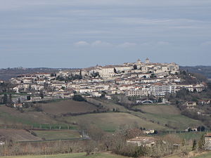
 View over Lauzerte |
||
Lauzerte is a French commune with 1,454 inhabitants (as of January 1, 2017) in the Tarn-et-Garonne department in the Occitanie region . The place belongs to the arrondissement Castelsarrasin and the canton Pays de Serres Sud-Quercy .
The long-distance hiking trail GR 65 leads through the village , which largely follows the historical course of the French Way of St. James, Via Podiensis . The association Les plus beaux villages de France declared Lauzerte one of the most beautiful villages in France .
Geography and traffic
Lauzerte is located in the Quercy-Blanc area . The landscape of the confluence of the Garonne and Tarn rivers is a limestone plateau that is cut through by many river valleys. The village of Lauzerte, which emerged from a medieval fortified village, is located on a hill between the two rivers Barguelonnette and Lendou .
The next cities are Cahors , which can be reached in a north-easterly direction via the D653 after about 38 kilometers of road, and Moissac , which can be reached in a south-westerly direction via the D2 - D957 after approximately 23 kilometers. The closest French cities are Toulouse (76 km) in the southeast, Bordeaux (152 km) in the northwest and Montpellier (231 km) in the southeast. Lauzerte is connected to the French trunk road network via the A62 Toulouse-Nord - Bordeaux and exits 8 (Valence-d'Agen) or 9 (Castelsarrasin).
The nearest train station is in Moissac and the nearest international airport is Toulouse-Blagnac Airport .
history
In the Gallo-Roman times, the hill of Lauzerte was a fortified place of the Gauls. The name of the place is said to be derived from the Latin name for lantern Lucerna , as the place is visible from afar like a light.
Lauzerte was founded as a fortified village by the Counts of Toulouse in the late 12th century and was later expanded into a bastide in order to be one of the fortified places to stop the advance of the English during the Hundred Years War . So the place guarded the road between Cahors and Moissac . Nevertheless, Lauzerte was partially destroyed and looted both in the Hundred Years War and during the wars of relegation .
From the 15th century, Lauzerte experienced a heyday with the seat of the court of appeal, which was responsible for hundreds of communities and which lasted until the 18th century. Another source of prosperity was the economic control of the surrounding towns and the care of the pilgrims on the Via Podiensis.
Way of St. James ( Via Podiensis )
There are three pilgrims' hostels (French: Gîte d'étape ), hotels and private rooms (French: Chambre d'hôtes ), as well as a campsite and a tourist information center.
The path continues through the hilly landscape of Tarn and Garonne to Moissac , the most important station on the Via Podiensis after Conques from a cultural and historical point of view . Other accommodations on the way to Moissac are in Durfort-Lacapelette and Saint-Martin-de-Durfort. The route D2 - D16 leads to Moissac as a road connection .
Attractions
- The historical part of Lauzerte is grouped around the market square with the Saint-Barthélemy church from the 13th century. In the 16th century it was fundamentally rebuilt and expanded. Many medieval and Renaissance houses frame the market square, standing on arcades.
- The Saint-Barthélemy church is located in the upper part of the village on the market square. The oldest parts of the church date from the 14th century. From 1591 to 1654, a pentagonal apse and six chapels were added. The wooden altarpiece of Mary is considered a baroque masterpiece.
- The Chapelle de l'hospice chapel was rebuilt in 1830 and today welcomes the pilgrims of the Via Podiensis.
- The church L'église des Carmes at the foot of the village is part of the former Carmelite monastery that was founded here in the 14th century. The single-nave church was rebuilt after its destruction in 1673.
- The 12th century Capuchin monastery was in operation until the French Revolution in 1789.
literature
- Bettina Forst: French Way of St. James. From Le Puy-en-Velay to Roncesvalles. All stages - with variants and height profiles. Bergverlag Rother, Munich [i. e.] Oberhaching, 4th edition 2015, ISBN 978-3-7633-4350-8 ( Rother hiking guide ).
- Bert Teklenborg: Cycling along the Camino de Santiago. From the Rhine to the western end of Europe. (Cycling guide, route planner). 3rd revised edition. Publishing House Tyrolia, Innsbruck 2007, ISBN 978-3-7022-2626-8 .
Web links
- Pictures from Lauzerte ( Memento from January 31, 2013 in the web archive archive.today )
- Office de Tourisme (French)
- Along the Via Podiensis
Individual evidence
- ↑ Lauzerte on Les plus Beaux Villages de France (French)
- ^ Community information on annuaire-mairie.fr (French); Retrieved January 21, 2010
← Previous location: Montcuq 14.5 km | Lurking | Next town: Durfort-Lacapelette 10.5 km →


