Cabrerets
| Cabrerets | ||
|---|---|---|
|
|
||
| region | Occitania | |
| Department | Lot | |
| Arrondissement | Cahors | |
| Canton | Causse et Vallées | |
| Community association | Grand Cahors | |
| Coordinates | 44 ° 30 ′ N , 1 ° 39 ′ E | |
| height | 130-367 m | |
| surface | 43.38 km 2 | |
| Residents | 229 (January 1, 2017) | |
| Population density | 5 inhabitants / km 2 | |
| Post Code | 46330 | |
| INSEE code | 46040 | |
| Website | Community website | |
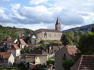
 Cabrerets and Church |
||
Cabrerets is a French commune in the department of Lot in the region Occitan (previously Midi-Pyrénées ). The small town with 229 inhabitants (as of January 1, 2017) is located in the Célé Valley and is part of the Causses du Quercy Regional Nature Park . The important prehistoric grotto Pech Merle is located in the municipality . The Célé variant of the French Way of St. James, Via Podiensis , runs through Cabrerets . This variant is marked as the GR 651 long-distance hiking trail .
geography
Cabrerets is located on the southwestern edge of the Massif Central on the banks of the Célé , a right tributary of the Lot , only about two kilometers before it flows into the Lot. The village stretches along the river and is partially dominated by the overhanging limestone cliffs of the Célé Valley. The village is ruled by the castle Château de Biron . The next town is Cahors , which can be reached through the valley of Célé and Lot in a westerly direction via the D41 , D662 and D663 after about 32 kilometers of road. The nearest major French cities are Toulouse (102 km) in the south, Bordeaux (181 km) in the northwest and Montpellier (203 km) in the southeast.
history
As early as prehistoric times, the area around Cabrerets was populated by people who used the caves in the cliffs above the Célé as a shelter. The Pech Merle grotto with its cave paintings and the attached prehistoric museum is particularly well known . The village castle was first mentioned in 1259 as the property of the Lords of Barasc , a noble family from Béduer . During the Hundred Years War it was conquered by the English in 1380. This is where the current name Château des Anglais comes from . Ten years later it was retaken and destroyed by Johannes von Hébrard, lord of Saint-Sulpice. In the 14th century a new castle was built, Château de Biron , which was rebuilt in the 16th century and belonged to the Marshal, Duke Charles de Gontaut . In the 19th century the castle was acquired by Count Murat, who undertook to restore and maintain the building.
Way of St. James ( Via Podiensis )
In the village or at the Pech Merle grotto there is a pilgrims' hostel (French: Gîte d'étape ), several hotels and a few private rooms (French: Chambre d'Hôtes ), as well as a campsite. The GR 651 variant leads past the Pech Merle grotto, crosses the Lot Valley at Saint-Cirq-Lapopie and reunites with the GR 65 between Limogne-en-Quercy and Varaire . As a road connection, the D41 runs parallel to the Way of St. James into the Lot Valley and then along the D662 to the road bridge over the Lot, which leads to the mountain village of Saint-Cirq-Lapopie .
Attractions
- The Grotte Pech Merle ( French Grotte du Pech Merle ) houses a large exhibition on the Paleolithic . Mammoths, bisons, horses and human figures are shown over a distance of 1200 meters. Prehistoric drawings can also be viewed.
- The archaeological site of the Grotte du Cantal is a 160 meter long cave with prehistoric drawings.
- In Cabrerets Castle , the parts still preserved today date from the early 16th and 17th centuries.
- Les Quatre Routes is the name of a dolmen and a menhir east of Cabrerets.
literature
- Bettina Forst: French Way of St. James. From Le Puy-en-Velay to Roncesvalles. All stages - with variants and height profiles. Bergverlag Rother, Munich (recte: Ottobrunn) 2007, ISBN 978-3-7633-4350-8 ( Rother hiking guide ).
- Bert Teklenborg: Cycling along the Camino de Santiago. From the Rhine to the western end of Europe. (Cycling guide, route planner). 3rd revised edition. Publishing House Tyrolia, Innsbruck 2007, ISBN 978-3-7022-2626-8 .
Web links
- [1] ( Memento from February 22, 2013 in the web archive archive.today ) [2] ( Memento from January 31, 2013 in the web archive archive.today ) Pictures from Cabrerets
Individual evidence
- ↑ Congregational information on annuaire-mairie.fr (French). Retrieved on January 21, 2010
← Previous location: Marcilhac-sur-Célé 6 km | Cabrerets | Next town: Saint-Cirq-Lapopie 11 km →
