
Cieurac
|
Cieurac Siurac |
||
|---|---|---|
|
||
| region | Occitania | |
| Department | Lot | |
| Arrondissement | Cahors | |
| Canton | Cahors-3 | |
| Community association | Grand Cahors | |
| Coordinates | 44 ° 22 ′ N , 1 ° 31 ′ E | |
| height | 189-292 m | |
| surface | 18.7 km 2 | |
| Residents | 550 (January 1, 2017) | |
| Population density | 29 inhabitants / km 2 | |
| Post Code | 46230 | |
| INSEE code | 46070 | |
| Website | http://www.cieurac.fr/ | |

Cieurac ( Occitan : Siurac ) is a French commune in the Lot department in the Occitanie region (before 2016: Midi-Pyrénées ). The municipality with 550 inhabitants (as of January 1, 2017) belongs to the arrondissement of Cahors and the canton of Cahors-3 (until 2015: canton of Lalbenque ).
geography
Cieurac is located about 13 kilometers south-southeast of the city center of Cahors on the southwestern edge of the Massif Central and the western edge of the Cevennes . Cieurac is surrounded by the neighboring communities of Flaujac-Poujols in the north, Laburgade in the northeast, Lalbenque in the east and southeast, Fontanès in the south, Lhospitalet in the southwest and Le Montat in the west.
The community is on the Via Podiensis , a variant of the Camino de Santiago . The A20 autoroute runs through them . The Cahors-Lalbenque airfield is also located in the municipality .
Population development
| 1962 | 1968 | 1975 | 1982 | 1990 | 1999 | 2006 | 2013 | |
|---|---|---|---|---|---|---|---|---|
| 233 | 212 | 229 | 279 | 264 | 287 | 402 | 483 | |
| Source: Cassini and INSEE | ||||||||
Attractions
- church
- Cieurac Castle, Monument historique
- Pauliac Castle
- Haute-Serre castle and domain
- Cieurac windmill, Monument historique

Cieurac Castle

Haute-Serre castle and domain
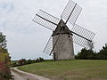
Cieurac windmill


