
Duravel
|
Duravel Duravèl |
||
|---|---|---|
.svg)
|
|
|
| region | Occitania | |
| Department | Lot | |
| Arrondissement | Cahors | |
| Canton | Puy-l'Évêque | |
| Community association | Vallée du Lot et du Vignoble | |
| Coordinates | 44 ° 31 ' N , 1 ° 5' E | |
| height | 65-271 m | |
| surface | 14.97 km 2 | |
| Residents | 965 (January 1, 2017) | |
| Population density | 64 inhabitants / km 2 | |
| Post Code | 46700 | |
| INSEE code | 46089 | |
 Duravel - the site |
||

Duravel ( Occitan : Duravèl ) is a southern French municipality ( commune ) with 965 inhabitants (as of January 1, 2017) in the Lot department in the Occitania region .
location
The place Duravel is about two kilometers from the north bank of the river Lot at an altitude of about 90 meters above sea level. d. M. in the old cultural landscape of the Quercy about 38 kilometers (driving distance) northwest of Cahors . The imposing ruins of the Château de Bonaguil are another five kilometers (as the crow flies) in a north-westerly direction.
Population development
| year | 1962 | 1968 | 1975 | 1982 | 1990 | 1999 | 2006 | 2012 |
| Residents | 823 | 983 | 911 | 875 | 894 | 882 | 930 | 957 |
In the 19th century, the place usually had between 1800 and over 3000 inhabitants. As a result of the phylloxera crisis in viticulture and the mechanization of agriculture , the number of inhabitants has since declined continuously to the lows in the 1950s and early 1960s.
economy
In the Quercy, agriculture, which included viticulture until the 19th century, was primarily self-sufficient for centuries . After the phylloxera crisis in the second half of the 19th century, viticulture was temporarily completely abandoned in the region, but red, rosé and white wines are now being produced again, which are marketed via the appellations Cahors , Comté Tolosan and Côtes du Lot . In addition to agriculture, the place plays a role for retail trade and crafts in the region; Tourism in the form of renting holiday apartments ( gîtes ) is also important for economic life.
history
Duravel was probably founded by the Romans as a way station on the road from Bordeaux ( Burdigala ) to Lyon ( Lugdunum ); In Gallo-Roman times there was an estate ( villa rustica ) nearby . There was a church here since the 5th or 6th century, which - later destroyed - was rebuilt in the 7th century. In the 11th century, took over Cluny under standing Benedictine - Saint-Pierre Abbey in Moissac control and they built a new priory in which the bones of the during the time of the Crusades spent from Palestine here Sts. Hilarion , Agathon and Poémon were worshiped. Her bones are in a stone sarcophagus in the church choir . During the Hundred Years War (1337–1453), the town, which had a population of 6,000 at that time, was temporarily occupied by the English; In 1455, the French King Charles VII gave him the present coat of arms with the insignia of the crown of France as thanks and recognition . Partly destroyed in the Huguenot Wars (1562–1598), the priory was dissolved in 1626; from then on the church served as a parish church.
Attractions

- The former priory church of Saint-Hilaire is an imposing 12th century building; its crossing tower towers over the place on the edge of the forest. It has a square crypt from the 11th century with four columns below the crossing; their capitals show elaborately crafted braided ribbon motifs as well as vegetable and abstract shapes and a peacock can also be recognized. The nave , which was partially destroyed in the Hundred Years' War and rebuilt with rebuilt columns and capitals, has three aisles and opens into a transept with a semicircular central apse and a lateral apse on the south side - broken polygonally on the outside - which was painted in the years 1837–1843 and restored or restored in 1884 . have been revised; the northern side apse was converted into a sacristy in the 16th or 17th century . The originally preserved architectural design of the south apse with superimposed (blind) arched arcades is noteworthy. The church originally had two portals - one on the west and one on the south, which led into the former enclosure ; the west façade and its portal were renewed in a Romanesque-Gothic mixed style in the 16th century and revised again in the 19th century. Church construction has been recognized as a monument historique since 1912 .

West facade

Nave and apse

Central apse

southern apse
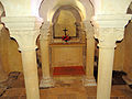
crypt

Capital with peacock


- The Château Boutier is a representative mansion from the 16th and 17th centuries. Century. It is privately owned and was added to the list of Monuments historiques in 1991.
- The apse ruin of the Romanesque church Saint-Avit , which now stands in a wooded property, but formerly belonged to a village , has also been classified as a monument historique since 1979 .
Web links
- Duravel, church - photos + information (French)
- Duravel, crypt of the church - photos + brief information (French)
- Duravel, Château Boutier - Photos + Info (French)
- Duravel, Château Boutier - photos + brief information (French)
- Duravel, apse of the Église Saint-Avit - photos + brief information (French)
Individual evidence
- ↑ Église Saint-Hilarion, Duravel in the Base Mérimée of the French Ministry of Culture (French)
- ↑ Château Boutier, Duravel in the Base Mérimée of the French Ministry of Culture (French)
- ↑ Église Saint-Avit, Duravel in the Base Mérimée of the French Ministry of Culture (French)