
Bach (Lot)
| Brook | ||
|---|---|---|
|
||
| region | Occitania | |
| Department | Lot | |
| Arrondissement | Cahors | |
| Canton | Marches du Sud-Quercy | |
| Community association | Pays de Lalbenque-Limogne | |
| Coordinates | 44 ° 21 ′ N , 1 ° 40 ′ E | |
| height | 220–337 m | |
| surface | 21.02 km 2 | |
| Residents | 178 (January 1, 2017) | |
| Population density | 8 inhabitants / km 2 | |
| Post Code | 46230 | |
| INSEE code | 46013 | |
 Entrance |
||

Bach is a French municipality with 178 inhabitants (at January 1, 2017) in the department of Lot in the Région Okzitanien (2015 Midi-Pyrenees ). It belongs to the Arrondissement of Cahors and the Pays de Lalbenque-Limogne municipal association founded in 1998 . The inhabitants are called bachois .
geography
The municipality is located about 25 kilometers southeast of Cahors in the Causse de Limogne , a part of the Quercy landscape in the Causses du Quercy Regional Nature Park . The calcareous soil does not allow any surface running water. The landscape is characterized by wide dry grasslands and larger forest areas ( Bois de Couanac, Bois d'Aubrelong ). A strand of the French Way of St. James, Via Podiensis , runs through Bach . This variant is marked as the GR 651 long-distance hiking trail . In the south, the municipality borders on the Tarn-et-Garonne department . Bach is surrounded by the neighboring communities of Concots in the north, Varaire in the northeast, Saillac in the east, Saint-Projet in the south, Vaylats in the southwest and Escamps in the west. The largest districts of the municipality of Bach are Les Bories Hautes, Estournel and Escabasse .
Place name
The place name Bach could come from the Old French Bach for reservoir or from the Occitan ubac for place in the north . The linguist Gaston Bazalgues favors a Germanic origin for a small river.
Population development
| year | 1962 | 1968 | 1975 | 1982 | 1990 | 1999 | 2006 | 2016 |
| Residents | 153 | 144 | 127 | 124 | 140 | 144 | 171 | 181 |
| Sources: Cassini and INSEE | ||||||||
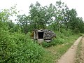
Attractions
- Church of the Assumption ( Église de l'Assomption-de-la-Vierge-Marie )
- Lavoir in the Escabasse district
- Casserole
- Floor cross

Church of the Assumption

Village square
Casserole

Floor cross


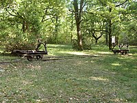
Phosphate mine "Phosphatière du Cloup d'Aural"
In the Quercy area, many " phosphate holes " were discovered in the 1870s and opened up for mining. The outcrops of Jurassic limestone between Cahors , Figeac , Gaillac and Montauban triggered a "phosphate fever", so that in 1886 161 mines were already in operation that produced 30,000 tons of phosphate fertilizer. In 1887 the yield of the deposits decreased and 112 mines were closed. The discovery of abundant phosphate deposits in North Africa made the French mines less economical. In 1902 only two mines (in Cajarc and Calvignac ) were still in operation. The scientific interest of the Cloup d'Aural phosphate mine was based on the occurrence of many vertebrate fossils that lived in the tertiary period between the end of the Eocene and the early Miocene, about 20 million years ago. For some of these fossils it served as an international reference for the standard sequence of the European fauna. More than 600 animal species have been identified in the phosphates. In order to prevent abandoned phosphate mines from degenerating into rubbish dumps and to curb the looting of fossils, the association “Les Phosphatières du Quercy” decided in 1992 to turn the former Cloup d'Aural mine into an open-air museum. It opened in the early summer of 2000. In addition, in June 2015 the state created the National Nature Reserve of Geological Interest of the Lot department ( Réserve naturelle nationale d'intérêt géologique du département du Lot ). The former Cloup d'Aural phosphate mine has been designated as a Monument historique since 1998 .
- Former phosphate mine


Economy and Infrastructure
In the municipality of Bach there is a bricklayer's business, a plumbing shop and a restaurant with traditional regional cuisine. In addition to tourism, agriculture also plays a role in the municipality. Seven farms are based in Bach (grain cultivation, horse, goat, sheep and pig breeding).
Five departmental roads meet in the municipality of Bach. There is a connection to the ( Autoroute A20 ) in Lalbenque , 18 kilometers to the west . Lalbenque station is on the railway line from Brive-la-Gaillarde via Capdenac to Toulouse ( Ligne de Brive-la-Gaillarde à Toulouse-Matabiau via Capdenac ).
supporting documents
- ↑ Gaston Bazalgues: Les noms des communes du Parc , Les cahiers scientifiques du Parc naturel régional des Causses du Quercy, 2014, Volume 1, p. 116 (PDF file, French)
- ↑ Bach on cassini.ehess.fr
- ↑ Bach on insee.fr
- ^ Entry in the Base Mérimée of the Ministry of Culture. Retrieved April 7, 2019 (French).
- ↑ Farmers in Bach on annuaire-mairie.fr (French)