Cajarc
| Cajarc | ||
|---|---|---|

|
|
|
| region | Occitania | |
| Department | Lot | |
| Arrondissement | Figeac | |
| Canton | Causse et Vallées ( main town ) | |
| Community association | Grand Figeac | |
| Coordinates | 44 ° 29 ′ N , 1 ° 51 ′ E | |
| height | 140-394 m | |
| surface | 25.10 km 2 | |
| Residents | 1,125 (January 1, 2017) | |
| Population density | 45 inhabitants / km 2 | |
| Post Code | 46160 | |
| INSEE code | 46045 | |
| Website | Community website | |
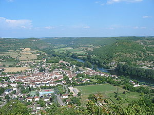
 View of Cajarc |
||
Cajarc is a French commune in the department of Lot in the region Occitania . The capital of the canton of Causse et Vallées is a medieval town framed by rocks with the remains of a fortification from the 13th century. The place with 1,125 inhabitants (as of January 1, 2017) became known through President Georges Pompidou , who had a country house here. The long-distance hiking trail GR 65 leads through Cajarc , which largely follows the historical course of the French Way of St. James ( Via Podiensis ).
geography
Cajarc is located on the southwestern edge of the Massif Central on the right bank of the Lot , framed by the rocks of the Lot Valley.
The next town is Cahors , which can be reached through the valley of the Lot, in a westerly direction via the D662 , D663 after about 50 kilometers of road. Alternatively there is the road connection via the Causse du Limogne, via the D19 and D911. The closest major French cities are Toulouse (103 km) in the south, Bordeaux (197 km) in the northwest and Montpellier (189 km) in the southeast. The municipality is part of the Causses du Quercy Regional Nature Park .
Population development
| year | 1962 | 1968 | 1975 | 1982 | 1990 | 1999 | 2006 |
| Residents | 1,020 | 1,044 | 1,028 | 1,059 | 1,033 | 1,114 | 1,088 |
In the 19th century the place had mostly between 1,800 and 2,200 inhabitants. As a result of the phylloxera crisis in viticulture and the mechanization of agriculture , the number of inhabitants fell continuously in the first half of the 20th century to the lows in the 1950s and 1960s.
economy
For centuries, agriculture in Haut-Quercy was primarily self-sufficient , which included viticulture until the 19th century, but which was almost completely given up after the phylloxera crisis . The place experienced a heyday in the 19th century, thanks to the tanneries, factories, mines and the phosphate transports by barge on the Lot. Today - in addition to agriculture, retail and handicrafts - tourism in the form of renting holiday apartments (French tourism association Gîtes de France ) plays an important role in the economic life of the municipality.
history
In the numerous grottos and caves in the region, there are often traces of primeval human activity. The dolmens also show that the area was inhabited as early as the Neolithic . The city of Caiac developed from the origins of a Roman settlement, which later became Cajarc. During the Hundred Years' War , like most French cities, Cajarc suffered from attacks by the English. It is probably thanks to the fortress above the city and massive defenses around the city that it was spared from English occupation. However, the bridge over the Lot was destroyed by the invaders in 1356. The bridge was replaced by a suspension bridge in 1842, which is still in operation today. During the Wars of Religion (1562–1598), Cajarc was a Protestant refuge for a long time. In January 1623 the city's fortress and defenses were destroyed on the orders of Cardinal Richelieu .
Way of St. James ( Via Podiensis )
In the Middle Ages, Cajarc was a transit station for pilgrims. The hospice, built in 1269, is mentioned in several texts and there has been a pilgrim bridge over the Lot since 1320.
Today Cajarc has two pilgrim hostels ( Gîtes d'étapes ), hotels and private accommodation ( Chambres d'hôtes ), as well as a campsite and a tourist office. This variant of the Camino de Santiago leads from the Lot Valley up to the limestone plateau of the Causse du Limogne. Through the sparsely populated landscape, it leads through fields and meadows as well as low oak and juniper stands. Many of the old farmsteads were given up in the course of the rural exodus and are now partially used as holiday homes. The next larger town is Limogne-en-Quercy , before the trail touches the Lot Valley in Cahors for the last time . The route D19 - D911 leads to Cahors as a road connection .
Attractions
- The small fortified Maison de l'Hébrardie dates in parts from the 12th / 13th centuries. Century. It was classified as a monument historique in 1924, mainly because of its Gothic windows . It is privately owned.
- The ruins of the Sainte-Madeleine chapel and its 12th century hospice . It served as a pilgrimage station and hospital for lepers.
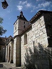
- The church of Cajarc was founded in the 13th century by Hébrard Aymeric Saint-Sulpice, Bishop of Coimbra . Thanks to donations from the Dukes of Rouergue and Toulouse , the church was expanded several times to serve as a place of pilgrimage. The dukes also had the bridge built over the Lot, which was destroyed in the Hundred Years War.
- The Romanesque apse of the Chapelle des Mariniers , made of quarry stone masonry and covered with stone shingles ( lauzes ) , was classified as a Monument historique in 1941 .
- Near the village is the Cascade de la Cogne waterfall with a height of 25 meters. Some of the most striking cliffs on the Lot bank have names, for example Roc de Conte and Château des Anglais .
- The train station on the Capdenac - Cahors line was built in 1885. Today the line is closed and the station houses a railway museum. The former station area, especially the water towers ( châteaux d'eau ), has been classified as a monument historique since 1989 .
- The Maison des Arts , which was built in 1989 in honor of Georges Pompidou, regularly shows retrospectives on the work of contemporary European artists.
- The dam in the Lot Valley in front of Cajarc was completed in 1946. It dams the Lot over a length of 2.5 kilometers and a width of around 100 meters. Both the French national championships and the world championships for motor sports boats were held on it in 1970 .
Events
Since 1999, the AfriCarjac festival has been taking place on the last weekend in July in the village and on the banks of the Lot . The multicultural festival for the whole family, combines music, film, dance, theater, visual arts, handicrafts, literature and street entertainment. It pursues the leitmotifs “respect for differences” and “openness to others”.
Personalities
- Françoise Sagan (1935–2004), writer
- Léon Solomiac (1884–1960), administrator
literature
- Bettina Forst: French Way of St. James. From Le Puy-en-Velay to Roncesvalles. All stages - with variants and height profiles. Bergverlag Rother, Munich (recte: Ottobrunn) 2007, ISBN 978-3-7633-4350-8 ( Rother hiking guide ).
- Bert Teklenborg: Cycling along the Camino de Santiago. From the Rhine to the western end of Europe. (Cycling guide, route planner). 3rd revised edition. Publishing House Tyrolia, Innsbruck 2007, ISBN 978-3-7022-2626-8 .
Web links
- [1] [2] Pictures of Cajarc and the Camino de Santiago
- Tourist Office (French)
- Along the Via Podiensis
- La Maison des Arts Georges Pompidou (French)
Individual evidence
- ↑ Congregational information on annuaire-mairie.fr (French). Retrieved on January 21, 2010
- ↑ Maison de l'Hébrardie, Cajarc in the Base Mérimée of the French Ministry of Culture (French)
- ↑ Chapelle Sainte-Marguerite dite des Mariniers, Cajarc in the Base Mérimée of the French Ministry of Culture (French)
- ↑ Gare, Cajarc in the Base Mérimée of the French Ministry of Culture (French)
← Previous location: Gréalou 10 km | Cajarc | Next town: Limogne-en-Quercy 17 km →


