Saint-Chels
|
Saint-Chels Sanch Èl |
||
|---|---|---|
|
|
||
| region | Occitania | |
| Department | Lot | |
| Arrondissement | Figeac | |
| Canton | Causse et Vallées | |
| Community association | Grand Figeac | |
| Coordinates | 44 ° 32 ' N , 1 ° 48' E | |
| height | 157-394 m | |
| surface | 17.86 km 2 | |
| Residents | 141 (January 1, 2017) | |
| Population density | 8 inhabitants / km 2 | |
| Post Code | 46160 | |
| INSEE code | 46254 | |
| Website | http://www.saint-chels.fr/ | |
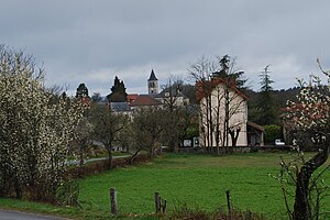
 Saint-Chels - the townscape |
||
Saint-Chels ( Occitan : Sanch Èl ) is a municipality in the south of France with 141 inhabitants (as of January 1, 2017). It is located in the cultural landscape of the Quercy in the Lot department in the Occitania region .
location
Saint-Chels lies between the Lot and Célé rivers at an altitude of approx. 350 meters above sea level. d. M. on the southwestern edge of the Massif Central . The nearest town, Figeac , is about 25 kilometers (driving distance) to the northeast.
Population development
| year | 1962 | 1968 | 1975 | 1982 | 1990 | 1999 | 2006 |
| Residents | 150 | 151 | 149 | 143 | 138 | 139 | 148 |
In the 19th century the place had more than 500 inhabitants at times. As a result of the phylloxera crisis in viticulture and the mechanization of agriculture , the number of inhabitants has since decreased continuously to the lowest level of the last decades.
economy
In the Haut-Quercy , agriculture was primarily self-sufficient , which also included viticulture until the 19th century, but which was almost completely abandoned after the phylloxera crisis . Today - in addition to cattle and poultry farming - tourism in the form of renting holiday apartments ( gîtes ) plays a major role in the economic life of the municipality.
history
Several Neolithic large stone graves ( dolmen ) in the area suggest that the area dates back to the 4th millennium BC. Was settled. In the Middle Ages and in the early modern period, Saint-Chels was part of the lordship ( seigneurie ) of Larnagol . During the Hundred Years War (1337-1453) the place was repeatedly besieged by English troops.
Attractions
- Several megalithic tombs can be found in the wooded area. Due to the limestone used , most of them are badly weathered and partially collapsed. Several of these Neolithic buildings can be explored on an approximately ten kilometer long circular hiking trail; some of them were recognized as Monuments historiques in 1988/89 .
- At the edges of the field there are stone huts ( caselles ) made of dry masonry .
- The local parish church was built in the 19th century.
Web links
Individual evidence
- ↑ Dolmen des Agars, Saint-Chels in the Base Mérimée of the French Ministry of Culture (French)
- ^ Dolmen d'Aubins, Saint-Chels in the Base Mérimée of the French Ministry of Culture (French)
- ↑ Dolmen du Mas de Pezet, Saint-Chels in the Base Mérimée of the French Ministry of Culture (French)
- ↑ Dolmen du Pech d'Agaïo, Saint-Chels in the Base Mérimée of the French Ministry of Culture (French)


