
Prudhomat
|
Prudhomat Prudomat |
||
|---|---|---|
|
||
| region | Occitania | |
| Department | Lot | |
| Arrondissement | Figeac | |
| Canton | Cère et Ségala | |
| Community association | Causses et Vallée de la Dordogne | |
| Coordinates | 44 ° 54 ' N , 1 ° 49' E | |
| height | 120-267 m | |
| surface | 12.39 km 2 | |
| Residents | 715 (January 1, 2017) | |
| Population density | 58 inhabitants / km 2 | |
| Post Code | 46130 | |
| INSEE code | 46228 | |
| Website | http://www.prudhomat.fr/public/ | |

Prudhomat ( Occitan : Prudomat ) is a French commune with 715 inhabitants (as of January 1, 2017) in the Lot department in the Occitanie region . It belongs to the arrondissement of Figeac and the canton of Cère et Ségala (until 2015: canton of Bretenoux ).
geography
Prudhomat is located 58 kilometers north-northeast of Cahors , in the very north of the Lot department. Here the river Cère flows into the Dordogne . Prudhomat is surrounded by the neighboring communities of Tauriac in the north and northwest, Girac in the north, Bretenoux in the northeast, Saint-Michel-Loubéjou in the east, Autoire in the southeast, Loubressac in the south and Gintrac in the west and southwest.
Population development
| year | 1962 | 1968 | 1975 | 1982 | 1990 | 1999 | 2006 | 2013 |
| Residents | 490 | 472 | 466 | 545 | 594 | 648 | 674 | 738 |
| Source: Cassini and INSEE | ||||||||
Attractions
- Saint-Gilles-de-Bonnevoie church from the 10th century, renovations from the 11th / 12th. Century, Monument historique since 1979
- Félènes Priory
- Chapel of Sainte-Marie in Félines, monument historique since 1913
- Castelnau-Bretenoux Castle, monument historique since 1862

Saint-Gilles-de-Bonnevoie Church
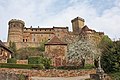
Castelnau-Bretenoux Castle


Web links
Commons : Prudhomat - collection of images, videos and audio files