
Montredon
| Montredon | ||
|---|---|---|
|
||
| region | Occitania | |
| Department | Lot | |
| Arrondissement | Figeac | |
| Canton | Figeac-2 | |
| Community association | Community de communes Grand-Figeac | |
| Coordinates | 44 ° 37 ′ N , 2 ° 12 ′ E | |
| height | 240-505 m | |
| surface | 11.78 km 2 | |
| Residents | 297 (January 1, 2017) | |
| Population density | 25 inhabitants / km 2 | |
| Post Code | 46270 | |
| INSEE code | 46207 | |
.jpg) Montredon |
||

Montredon is a French commune with 297 inhabitants (as of January 1, 2017) in the Lot department in the Occitanie region . It belongs to the Arrondissement of Figeac and the Canton of Figeac-2 .
Neighboring municipalities are Bagnac-sur-Célé in the northwest, Saint-Santin-de-Maurs in the north, Montmurat in the east, Livinhac-le-Haut in the southeast, Bouillac in the south and Felzins in the west.
Population development
| year | 1962 | 1968 | 1975 | 1982 | 1990 | 1999 | 2008 | 2015 |
|---|---|---|---|---|---|---|---|---|
| Residents | 322 | 302 | 301 | 288 | 263 | 286 | 288 | 291 |
Attractions

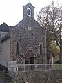
Saint-Michel church
Notre-Dame de Pitité chapel


The 20 km long section of the French Way of St. James, Via Podiensis, from Montredon to Figeac is now a listed building.
economy
The vines in Montredon are located in the Corbières wine region .
Web links
Commons : Montredon - collection of images, videos and audio files
Individual evidence
- ^ Bettina Forst: French Way of St. James. From Le Puy-en-Velay to Roncesvalles. All stages - with variants and height profiles. Bergverlag Rother, Munich (recte: Ottobrunn) 2007, ISBN 978-3-7633-4350-8 ( Rother hiking guide ). P. 83
Way of St. James " Via Podiensis "
← Previous location: Livinhac-le-Haut 6 km | Montredon | Next town: Saint-Félix (Lot) 9.8 km →