
Saint-Christophe-sur-Dolaison
| Saint-Christophe-sur-Dolaison | ||
|---|---|---|
|
||
| region | Auvergne-Rhône-Alpes | |
| Department | Haute Loire | |
| Arrondissement | Le Puy-en-Velay | |
| Canton | Velay volcanique | |
| Community association | Puy-en-Velay | |
| Coordinates | 45 ° 0 ′ N , 3 ° 49 ′ E | |
| height | 763–1,069 m | |
| surface | 27.34 km 2 | |
| Residents | 953 (January 1, 2017) | |
| Population density | 35 inhabitants / km 2 | |
| Post Code | 43370 | |
| INSEE code | 43174 | |

The French municipality of Saint-Christophe-sur-Dolaison is located in the department of Haute-Loire in the region Auvergne Rhône-Alpes . The place with 953 inhabitants (as of January 1, 2017) is on the GR 65 long-distance hiking trail , which largely follows the historical course of the French Way of St. James Via Podiensis .
It is classified as a French mountain community and therefore enjoys special advantages in agriculture and planning law.
geography
Saint-Christophe-sur-Dolaison is a place in the Massif Central and belongs to the Velay landscape . It is located at the intersection of the D906 and the D31 about 8 kilometers from Le Puy-en-Velay . The closest major French cities are Lyon (116 km) in the northeast, Toulouse (244 km) in the southwest, Bordeaux (348 km) in the west and Montpellier (154 km) in the south. The nearest train station is in Le Puy-en-Velay.
history
The town's castle and castle are mentioned as early as the 15th century.
During the French Revolution , Saint-Christophe-sur-Dolaison was given the name Christophe or Christophe-la-Montagne.
Agricultural products are sold under the protected designation of origin Appellation d'Origine Contrôlée (AOC) Lentille verte du Puy .
Attractions
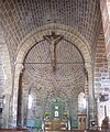
- The Church of St. Christopher dates back to the 12th century and was first mentioned in 1161 in the Templar Hospital of Le Puy-de-Valay. It is built entirely from the reddish volcanic rock of the region and has a pretty bell tower.

Church of St. Christopher


- In the village you can also see the remains of an old village bakery . The villagers baked bread and pies in the oven heated by sticks.
Way of St. James ( Via Podiensis )
Saint-Christophe-sur-Dolaison is the second place after La Roche on the French Way of St. James Via Podiensis and is about 8.5 kilometers from Le Puy-en-Velay on the GR 65 long-distance hiking trail . There are two private hostels in the village. The historic route of the Camino de Santiago continues to Bains , while the GR 65 leads via Montbonnet to Saint-Privat-d'Allier . The direct road connection runs on the D31 to Séneujols , then on to the D621 to Montbonnet and the D589 to Saint-Privat-d'Allier.
literature
- Bettina Forst: French Way of St. James. From Le Puy-en-Velay to Roncesvalles. All stages - with variants and height profiles (= Rother hiking guide ). Bergverlag Rother, Munich (recte: Ottobrunn) 2007, ISBN 978-3-7633-4350-8
- Bert Teklenborg: Cycling along the Camino de Santiago. From the Rhine to the western end of Europe. (Cycling guide, route planner). 3rd, revised edition. Publishing House Tyrolia, Innsbruck 2007, ISBN 978-3-7022-2626-8 .
Web links
- Pictures along the via Podiensis ( Memento from January 31, 2013 in the web archive archive.today )
- Along the Via Podiensis
Individual evidence
- ↑ Congregational information on annuaire-mairie.fr (French). Retrieved on January 21, 2010
← Previous location: Le Puy-en-Velay 8.5 km | Saint-Christophe-sur-Dolaison | Next town: Bains 8.5 km GR65: Montbonnet 8.5 km →