
Saint-Vincent (Haute-Loire)
| Saint Vincent | ||
|---|---|---|
|
||
| region | Auvergne-Rhône-Alpes | |
| Department | Haute Loire | |
| Arrondissement | Le Puy-en-Velay | |
| Canton | Emblavez-et-Meygal | |
| Community association | Communauté d'agglomération du Puy-en-Velay | |
| Coordinates | 45 ° 9 ' N , 3 ° 55' E | |
| height | 528-932 m | |
| surface | 20.4 km 2 | |
| Residents | 1,012 (January 1, 2017) | |
| Population density | 50 inhabitants / km 2 | |
| Post Code | 43800 | |
| INSEE code | 43230 | |
_-_Mairie.jpg) Town hall (Mairie) of Saint-Vincent |
||

Saint-Vincent is a French commune with 1,012 inhabitants (at January 1, 2017) in the department of Haute-Loire in the region Auvergne Rhône-Alpes (before 2016 Auvergne ); it belongs to the arrondissement Le Puy-en-Velay and the canton Emblavez-et-Meygal (until 2015 Saint-Paulien ).
geography
Saint-Vincent is located about twelve kilometers north-northeast of Le Puy-en-Velay in the Velay countryside and on the Loire , which borders the municipality to the east. Saint-Vincent is surrounded by the neighboring communities of Vorey in the north, Beaulieu in the east and south-east, Lavoûte-sur-Loire in the south, Saint-Paulien in the west and Saint-Geneys-près-Saint-Paulien in the north-west.
Population development
| year | 1962 | 1968 | 1975 | 1982 | 1990 | 1999 | 2006 | 2013 |
| Residents | 759 | 709 | 731 | 775 | 806 | 831 | 937 | 983 |
| Source: Cassini and INSEE | ||||||||
Attractions
- Saint Vincent Church
- Remains of the Ceneuil Castle
- Margeaix Bridge, built 1897–1898, Monument historique since 1994

Saint Vincent Church
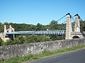
Margeaix suspension bridge
_-_Clocher.jpg)

Web links
Commons : Saint-Vincent - Collection of images, videos and audio files