Saint-Privat-d'Allier
| Saint-Privat-d'Allier | ||
|---|---|---|
|
|
||
| region | Auvergne-Rhône-Alpes | |
| Department | Haute Loire | |
| Arrondissement | Le Puy-en-Velay | |
| Canton | Saint-Paulien | |
| Community association | Puy-en-Velay | |
| Coordinates | 44 ° 59 ′ N , 3 ° 41 ′ E | |
| height | 547-1,221 m | |
| surface | 37.67 km 2 | |
| Residents | 398 (January 1, 2017) | |
| Population density | 11 inhabitants / km 2 | |
| Post Code | 43580 | |
| INSEE code | 43221 | |
| Website | Community website | |
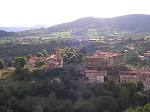
 View of the Saint-Privat church |
||
The French commune of Saint-Privat-d'Allier is located in the department of Haute-Loire in the region Auvergne Rhône-Alpes . The municipality with 398 inhabitants (as of January 1, 2017) is located on the GR 65 long-distance hiking trail , which largely follows the historical course of the French Way of St. James Via Podiensis .
geography
Saint-Privat-d'Allier is located in the Massif Central in the Allier Gorge . The gorge separates the landscape of the Velay in the west from the plateau of the Margeride in the east. The village lies on a rock spur above the Allier valley. The closest major French cities are Lyon (125 km) in the northeast, Toulouse (235 km) in the southwest, Bordeaux (337 km) in the west and Montpellier (154 km) in the south.
Transport links
Saint-Privat-d'Allier is connected to the administrative capital Le Puy-en-Velay via the D589 , which runs eastwards via Bains .
history
A castle from the 13th century was built by the noble family of Mercœur Montlaur . However, large parts of the castle were destroyed in the 17th century.
The village developed mainly because of its location on Via Podiensis . Today it is an important base for white water sports enthusiasts on the Allier River.
On January 1, 2017, the municipality of Saint-Didier-d'Allier was incorporated.
structure
| District | former INSEE code |
Area (km²) | Population (2016) |
|---|---|---|---|
| Saint-Didier-d'Allier | 43176 | 7.71 | 41 |
| Saint-Privat-d'Allier (administrative headquarters) | 43221 | 29.96 | 364 |
Way of St. James ( Via Podiensis )
In Saint-Privat-d'Allier there is a tourist information office, a hotel and restaurant, as well as several pilgrimage hostels (French: Gîte d'étape ). The next larger town on the Camino de Santiago is Monistrol-d'Allier . The D589 leads there as a direct road connection .
Attractions
- There is a Romanesque church and an old abbey founded in the 11th century by monks from the Benedictine monastery in La Chaise-Dieu .
- The volcanic cliffs rising from the Allier and formed as basalt columns are remarkable in terms of landscape .
- The metal sculpture of the beast of Gévaudan is intended to attract tourist attention in particular .
literature
- Bettina Forst: French Way of St. James. From Le Puy-en-Velay to Roncesvalles. All stages - with variants and height profiles (= Rother hiking guide ). Bergverlag Rother, Munich (recte: Ottobrunn) 2007, ISBN 978-3-7633-4350-8 .
- Bert Teklenborg: Cycling along the Camino de Santiago. From the Rhine to the western end of Europe. (Cycling guide, route planner). 3rd, revised edition. Publishing House Tyrolia, Innsbruck 2007, ISBN 978-3-7022-2626-8 .
Web links
- Pictures along the Via Podiensis ( Memento from January 31, 2013 in the web archive archive.today )
- Along the Via Podiensis
Individual evidence
- ^ Community information on annuaire-mairie.fr (French). Retrieved January 21, 2010.
- ↑ Population figures retrospectively from January 1, 2016
← Previous location: Bains 10 km | Saint-Privat-d'Allier | Next town: Monistrol-d'Allier 6 km →

