Rosières (Haute-Loire)
| Rosières | ||
|---|---|---|
|
|
||
| region | Auvergne-Rhône-Alpes | |
| Department | Haute Loire | |
| Arrondissement | Le Puy-en-Velay | |
| Canton | Emblavez-et-Meygal | |
| Community association | Puy-en-Velay | |
| Coordinates | 45 ° 8 ′ N , 3 ° 59 ′ E | |
| height | 594–1,072 m | |
| surface | 26.82 km 2 | |
| Residents | 1,528 (January 1, 2017) | |
| Population density | 57 inhabitants / km 2 | |
| Post Code | 43800 | |
| INSEE code | 43165 | |
| Website | http://www.ville-rosieres.fr | |
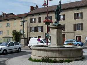
 Place Jeanne d'Arc in Rosières |
||
Rosières is a commune with 1,528 inhabitants (at January 1, 2017) in the department of Haute-Loire in the region Auvergne Rhône-Alpes . It belongs to the arrondissement of Le Puy-en-Velay and the canton of Emblavez-et-Meygal .
geography
The municipality is located in the natural landscape of Emblavès (also written Emblavez ), around 50 kilometers southwest of Saint-Étienne and 13 kilometers northeast of Le Puy-en-Velay . Neighboring communities are:
- Mézères in the north,
- Saint-Julien-du-Pinet in the east,
- Le Pertuis in the southeast
- Saint-Étienne-Lardeyrol in the south,
- Malrevers in the southwest,
- Beaulieu to the west and
- Chamalières-sur-Loire in the north-west.
The municipality is drained from the river Suissesse with its tributaries towards the west to the Loire .
Transport links
Rosières is located off the national traffic routes and is connected to its neighboring communities via the D7 and D71 département roads. Between 1890 and 1952 the place was opened up by the railway connection La Galoche between Lavoûte-sur-Loire and Yssingeaux . The line was then discontinued and the route removed.
geology
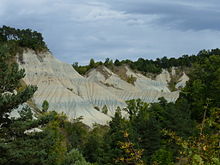
Rosières lies partly in the Emblavès plain, the formation of which goes back to the Tertiary . The layers of clay , descended from the primordial seas of the Massif Central , covered granite formations , some of which, like the Emblavès basin, have sunk. The municipal area does not only extend in the plain, there are also elevations of volcanic origin, which were formed about 13 million years ago by the eruption of lava . When it was viscous, it would pool to form a dome called suc, such as B. the current surveys Suc de Rougeac , Suc de la Mûre and Suc de Jalore . Through this volcanic activity, the power of the flowing waters was activated: the clay layers were cleared by erosion and today show their different colors in some places, the generally whitish color of which is interrupted by red, green, blue and ocher-yellow intermediate layers .
Population development
| year | 1968 | 1975 | 1982 | 1990 | 1999 | 2008 | 2016 |
| Residents | 1284 | 1163 | 1212 | 1305 | 1309 | 1438 | 1532 |
Attractions
- Saint Martin church from the 12th century, monument historique
- Calvaire du Champ Clos , 19th century cross, Monument historique
- Ravin de Corbœuf
- About a kilometer east of Rosières is the canyon of the Corbœuf brook. In the middle of a lush green landscape there is a gorge with whitish rock walls that are more reminiscent of sand dunes and impress with their colored bands. The viewpoint can be reached via the former "La Galoche" railway line.
Partner municipality
There is a partnership with Villar San Costanzo in Italy .
Web links
Individual evidence
- ↑ Geological information
- ↑ Église Saint Martin in the Base Mérimée of the French Ministry of Culture (French)
- ↑ Calvaire du Champ Clos in the Base Mérimée of the French Ministry of Culture (French)

