Saint-Pierre-Eynac
| Saint-Pierre-Eynac | ||
|---|---|---|
|
|
||
| region | Auvergne-Rhône-Alpes | |
| Department | Haute Loire | |
| Arrondissement | Le Puy-en-Velay | |
| Canton | Emblavez-et-Meygal | |
| Community association | Mézenc-Loire-Meygal | |
| Coordinates | 45 ° 3 ' N , 4 ° 2' E | |
| height | 685–1,070 m | |
| surface | 23.99 km 2 | |
| Residents | 1,147 (January 1, 2017) | |
| Population density | 48 inhabitants / km 2 | |
| Post Code | 43260 | |
| INSEE code | 43218 | |
 Town hall (Mairie) of Saint-Pierre-Eynac |
||
Saint-Pierre-Eynac is a French commune with 1,147 inhabitants (as of January 1 2017) in the department of Haute-Loire in the region Auvergne Rhône-Alpes ; it belongs to the arrondissement Le Puy-en-Velay and the canton Emblavez-et-Meygal (until 2015: canton Saint-Julien-Chapteuil ).
geography
Saint-Pierre-Eynac is located about eleven kilometers east of Le Puy-en-Velay in the Velay countryside . Saint-Pierre-Eynac is surrounded by the neighboring communities of Saint-Étienne-Lardeyrol in the north and north-west, Saint-Hostien in the north, Queyrières in the north-east, Saint-Julien-Chapteuil in the east, Saint-Germain-Laprade in the south and west and Blavozy in the West and northwest.
Population development
| year | 1962 | 1968 | 1975 | 1982 | 1990 | 1999 | 2006 | 2013 |
| Residents | 667 | 636 | 618 | 664 | 775 | 847 | 968 | 1,083 |
| Source: Cassini and INSEE | ||||||||
Attractions
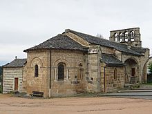
- Saint-Pierre church from the 11th / 12th centuries Century, conversions from the 13th and 15th centuries, Monument historique
- Bonneville Castle, Monument historique since 1973
- Lardeyrol Castle
- Eydac Castle
Web links
Commons : Saint-Pierre-Eynac - collection of images, videos and audio files

