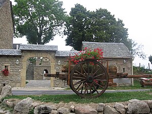
Golinhac
| Golinhac | ||
|---|---|---|

|
|
|
| region | Occitania | |
| Department | Aveyron | |
| Arrondissement | Rodez | |
| Canton | Lot et Truyère | |
| Community association | Comtal Lot and Truyère | |
| Coordinates | 44 ° 36 ' N , 2 ° 35' E | |
| height | 229-694 m | |
| surface | 32.41 km 2 | |
| Residents | 336 (January 1, 2017) | |
| Population density | 10 inhabitants / km 2 | |
| Post Code | 12140 | |
| INSEE code | 12110 | |

|
||
The municipality of Golinhac with 336 inhabitants (as of January 1, 2017) is located in the French region of Occitania in the Aveyron department . The place is on the long-distance hiking trail GR 65 , which largely follows the historical course of the French Way of St. James " Via Podiensis ".
geography
Golinhac is located in the Massif Central, south of the Lot Valley in the Estaing - Entraygues-sur-Truyère section . The closest major French cities are Lyon (218 km) in the northeast, Toulouse (144 km) in the southwest, Bordeaux (252 km) in the west and Montpellier (151 km) in the southeast.
history
The place originated in the 11th century on an old Roman road. The pre-Romanesque church with Gothic additions served as a fortified church until the 17th century.
| year | 1793 | 1800 | 1836 | 1866 | 1901 | 1936 | 1962 | 1982 | 1990 | 1999 | 2006 | 2016 |
|---|---|---|---|---|---|---|---|---|---|---|---|---|
| Residents | 760 | 1,376 | 1,061 | 1,209 | 1,050 | 761 | 541 | 472 | 458 | 392 | 441 | 343 |
Way of St. James ( Via Podiensis )
There is very limited accommodation in Golinhac. There is a simple pilgrim hostel (French: Gîte d'étape ) on the campsite . The next larger town on the Camino de Santiago is Conques . The path leads there in undulating relief over dirt roads and small roads through mixed forests and meadows. The road connection there is the D20 , which after a few kilometers leads to the D42, which you follow to Conques.
Attractions
- 15th century pilgrim cross
- Saint-Martin church , the beginnings of which date back to 950 with the foundations of a Benedictine abbey from the 12th century
literature
- Bettina Forst: French Way of St. James. From Le Puy-en-Velay to Roncesvalles. All stages - with variants and height profiles. Bergverlag Rother, Munich (recte: Ottobrunn) 2007, ISBN 978-3-7633-4350-8 ( Rother hiking guide ).
- Bert Teklenborg: Cycling along the Camino de Santiago. From the Rhine to the western end of Europe. (Cycling guide, route planner). 3rd revised edition. Publishing House Tyrolia, Innsbruck 2007, ISBN 978-3-7022-2626-8 .
Web links
- Landscape of Golinhac ( Memento from February 1, 2013 in the web archive archive.today )
- Along the Via Podiensis
Individual evidence
- ↑ Congregational information on annuaire-mairie.fr (French). Retrieved on January 21, 2010
- ↑ Golinhac on Cassini.ehess.fr (French). Retrieved February 4, 2010
