
Marcillac-Vallon
| Marcillac-Vallon | ||
|---|---|---|
.svg)
|
|
|
| region | Occitania | |
| Department | Aveyron | |
| Arrondissement | Rodez | |
| Canton | Vallon | |
| Community association | Conques-Marcillac | |
| Coordinates | 44 ° 28 ′ N , 2 ° 28 ′ E | |
| height | 275-534 m | |
| surface | 14.59 km 2 | |
| Residents | 1,707 (January 1, 2017) | |
| Population density | 117 inhabitants / km 2 | |
| Post Code | 12330 | |
| INSEE code | 12138 | |
| Website | http://www.marcillacvallon.fr/ | |
 Marcillac-Vallon Town Hall |
||

Marcillac-Vallon is a French commune in the Aveyron department in the Occitania region with 1,707 inhabitants (as of January 1, 2017). The municipality belongs to the arrondissement of Rodez and the canton of Vallon (until 2015: canton of Marcillac-Vallon ). The inhabitants are called Marcillacois .
geography
Marcillac-Vallon is located in the Marcillac wine-growing region , part of the Sud-Ouest wine-growing region , on the Créneau River , into which the Ady flows here. Marcillac-Vallon is surrounded by the neighboring communities of Nauviale in the north and north-west, Mouret in the north-east, Salles-la-Source in the south and east, Valady in the south and south-west and Saint-Christophe-Vallon in the west.
The former Routes nationales 601 (today's D901) and Route nationale 662 (today's D962) run through the municipality .

Population development
| 1962 | 1968 | 1975 | 1982 | 1990 | 1999 | 2006 | 2012 |
|---|---|---|---|---|---|---|---|
| 1,184 | 1,370 | 1,493 | 1,564 | 1,485 | 1,532 | 1,613 | 1,672 |
| Source: Cassini and INSEE | |||||||
Attractions
- Notre-Dame chapel in Foncorrieu, a historic monument since 1988
- Curlande mansion, Monument historique since 2001
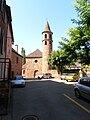
Notre-Dame chapel

Medieval town center

