
Sainte-Radegonde (Aveyron)
|
Sainte-Radegonde Senta Radegonda |
||
|---|---|---|

|
|
|
| region | Occitania | |
| Department | Aveyron | |
| Arrondissement | Rodez | |
| Canton | North Lévezou | |
| Community association | Rodez agglomeration | |
| Coordinates | 44 ° 20 ′ N , 2 ° 38 ′ E | |
| height | 535-791 m | |
| surface | 30.48 km 2 | |
| Residents | 1,756 (January 1, 2017) | |
| Population density | 58 inhabitants / km 2 | |
| Post Code | 12000 | |
| INSEE code | 12241 | |
| Website | www.sainteradegonde.fr | |

Sainte-Radegonde ( Occitan : Senta Radegonda ) is a French commune with 1,756 inhabitants (as of January 1, 2017) in the Occitanie region . It belongs to the Aveyron department , the Rodez arrondissement and the Nord-Lévezou canton (until 2015: Rodez-Est canton ). The inhabitants are called Radegondia .
geography
Sainte-Radegonde is located about four kilometers southeast of Rodez on the Garrigue River . Sainte-Radegonde is surrounded by the neighboring communities of Onet-le-Château in the north and north-west, La Loubière in the north-east, Agen d'Aveyron in the east, Le Vibal in the south-east, Flavin in the south and south-west, Le Monastère in the west and Rodez in the north-west.
history
On August 17, 1944, German troops massacred 30 civilians in Sainte-Radegonde who belonged to the Resistance or who (even allegedly) supported it.
Population development
| year | 1962 | 1968 | 1975 | 1982 | 1990 | 1999 | 2006 | 2012 |
|---|---|---|---|---|---|---|---|---|
| Residents | 480 | 443 | 542 | 1,027 | 1,226 | 1,355 | 1,536 | 1,707 |
| Source: Cassini and INSEE | ||||||||
Attractions
- Fortified church of Inières, monument historique since 1921 since 1921
- Fortified church of Sainte-Radegonde from the 14th century, monument historique since 1925
- Yence house from the 16th century, monument historique since 1978

Inières fortified church

Church of Sainte-Radegonde
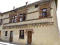
House Yence


_-_Maison_avec_fa%C3%A7ade_du_XVIe_si%C3%A8cle.JPG)
Personalities
- Paul Wormser (1901–1944), fencer, bronze medalist (1936)