
Toboggan
|
Rodelle Rodesla |
||
|---|---|---|
|
||
| region | Occitania | |
| Department | Aveyron | |
| Arrondissement | Rodez | |
| Canton | Causse-Comtal | |
| Community association | Comtal Lot and Truyère | |
| Coordinates | 44 ° 29 ′ N , 2 ° 38 ′ E | |
| height | 320-606 m | |
| surface | 53.43 km 2 | |
| Residents | 1,066 (January 1, 2017) | |
| Population density | 20 inhabitants / km 2 | |
| Post Code | 12340 | |
| INSEE code | 12201 | |
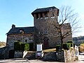
 Town hall (Mairie) of Rodelle |
||

Rodelle ( Occitan : Rodesla ) is a French commune with 1,066 inhabitants (as of January 1, 2017) in the Aveyron department of the Occitania region ; it belongs to the arrondissement of Rodez and the canton of Causse-Comtal . The inhabitants are called Rodellois .
geography
Rodelle is located about 14 kilometers north-northeast of Rodez in the Causse landscape , the so-called Causse du Comtal . Rodelle is surrounded by the neighboring communities of Sébrazac in the north and north-east, Bozouls in the east, Sébazac-Concourès in the south and south-east, La Loubière in the south, Salles-la-Source in the west and south-west, Muret-le-Château in the west and Villecomtal in the north-west .
Population development
| year | 1962 | 1968 | 1975 | 1982 | 1990 | 1999 | 2006 | 2013 |
| Residents | 942 | 884 | 759 | 743 | 845 | 889 | 943 | 1,052 |
| Source: Cassini and INSEE | ||||||||
Attractions
- Dolmen Le Roc de la Françoune , Monument historique since 1994
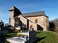
- Saint-Michel church from the 13th century, historic monument since 1991
- Lanhac church from the 15th century, monument historique since 1983
- Saint-Saturnin Church in Maymac
- Dalmayrac Castle, Monument historique since 1993
- Sanhes Castle
Saint-Michel church

Lanhac Church
Saint-Saturnin Church

Dalmayrac Castle

Sanhes Castle


.JPG)