
Pomayrols
|
Pomayrols Pomairòls |
||
|---|---|---|

|
|
|
| region | Occitania | |
| Department | Aveyron | |
| Arrondissement | Rodez | |
| Canton | Lot et Palanges | |
| Community association | Causses à l'Aubrac | |
| Coordinates | 44 ° 28 ′ N , 3 ° 2 ′ E | |
| height | 433-1,180 m | |
| surface | 23.4 km 2 | |
| Residents | 119 (January 1, 2017) | |
| Population density | 5 inhabitants / km 2 | |
| Post Code | 12130 | |
| INSEE code | 12184 | |
 Town Hall (Mairie) of Pomayrols |
||

Pomayrols ( Occitan Pomairòls ) is a French commune with 119 inhabitants (as of January 1, 2017) in the Aveyron department in the Occitania region (before 2016 Midi-Pyrénées ). Administratively it belongs to the Arrondissement of Rodez and is part of the canton of Lot et Palanges (until 2015 Saint-Geniez-d'Olt ). The inhabitants are called Pomayrolais .
geography
Pomayrols is about fifty kilometers east-northeast of Rodez . Pomayrols is surrounded by the neighboring communities of Saint Geniez d'Olt et d'Aubrac in the north and west, Trélans in the east and north-east, Saint-Laurent-d'Olt in the south and south-east and La Capelle-Bonance in the west and north-west.
Population development
| year | 1962 | 1968 | 1975 | 1982 | 1990 | 1999 | 2006 | 2013 |
| Residents | 290 | 283 | 246 | 178 | 182 | 152 | 156 | 130 |
| Source: Cassini and INSEE | ||||||||
Attractions
- 11th century Saint-Jean-Baptiste church
- Sainte-Madeleine church in La Fage from the 11th century
- Saint-Roch church in La-Boulesq
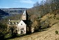
- 11th century Pomayrols Castle
- Chipole Bridge

Saint-Jean-Baptiste church
Sainte-Madeleine church

Saint-Roch church

Pomayrols Castle

Chipole Bridge


